1960s Maps of Lilburn, Georgia
Explore 1 historic maps of Lilburn from the 1960s. These maps offer a rare glimpse into what life looked like during the 1960s — showing old roads, neighborhoods, homes, and landmarks that have changed or disappeared over time.
Whether you're researching your family's past, planning a metal detecting trip, or studying how Lilburn's landscape evolved across the 1960s, these high-resolution maps are a powerful tool for exploring the history of this region.
- Focus on a specific era: All maps on this page are from the 1960s, giving you a focused view of this time period.
- See what’s changed: Compare century-old streets, trails, and buildings to today's modern landscape using overlays and satellite layers.
- Research with precision: Use these maps for genealogy, historical research, land use analysis, or educational projects.
- View, download, or print: Maps are fully viewable online in high resolution, and can be downloaded or printed for your own records.
Start exploring Lilburn's history through authentic maps from the 1960s. This is your window into the past.
Lilburn, GA maps
(1)- 1963 Map of Luxomni, 1965 Print
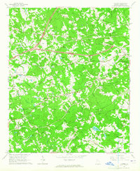 1963 Luxomni1965 Print · USGSGwinnett County during the early sixties shows a landscape of established rail towns and early interstate development. Genealogists and historians can trace the foundations of Luxomni, Gloster, and Bethesda, alongside rural landmarks like Lebanon Ch and Fairview Cem.4 unique versions available
End of results
Showing maps 1-1 of 1
Top cities near Lilburn
- Atlanta historical maps
- Sandy Springs historical maps
- Roswell historical maps
- Johns Creek historical maps
- Alpharetta historical maps
- Stonecrest historical maps
See more
Top neighborhoods of Lilburn
- Luxomni historical maps
- Legends at Parkview historical maps
- Michelle Estates historical maps
- Nantucket historical maps
- Sarann Woods historical maps
- Stoneview Acres historical maps
See more
Frequently asked questions
- What are the different types of historical maps available for Lilburn?
- What is the oldest map of Lilburn?
- Where can I purchase historical maps of Lilburn for my home or office?
- Where can I download high-res historical maps of Lilburn?
- Are there historical topographic maps available for Lilburn?
- Is there historical aerial imagery available for Lilburn?
- Where are historical maps of Lilburn sourced from?