1960s Maps of Habersham County, Georgia
Explore 6 historic maps of Habersham County from the 1960s. These maps offer a rare glimpse into what life looked like during the 1960s — showing old roads, neighborhoods, homes, and landmarks that have changed or disappeared over time.
Whether you're researching your family's past, planning a metal detecting trip, or studying how Habersham County's landscape evolved across the 1960s, these high-resolution maps are a powerful tool for exploring the history of this region.
- Focus on a specific era: All maps on this page are from the 1960s, giving you a focused view of this time period.
- See what’s changed: Compare century-old streets, trails, and buildings to today's modern landscape using overlays and satellite layers.
- Research with precision: Use these maps for genealogy, historical research, land use analysis, or educational projects.
- View, download, or print: Maps are fully viewable online in high resolution, and can be downloaded or printed for your own records.
Start exploring Habersham County's history through authentic maps from the 1960s. This is your window into the past.
Habersham County, GA maps
(6)- 1964 Map of Ayersville, 1965 Print
 1964 Ayersville1965 Print · USGSNortheast Georgia in the mid-sixties reveals a landscape of national forest land, mountain ridges, and rail-side settlements. Genealogists and historians can trace family-named sites like Shorts Mill, Ducket Lake, and churches such as Mt Bethel Ch or Antioch Ch.3 unique versions available
 - 1964 Map of Lula, 1965 Print
 1964 Lula1965 Print · USGSThe foothills of northeast Georgia meet the expanding shoreline of Lake Sidney Lanier in the mid-1960s. Genealogists can trace rural communities through landmarks like Skitts Mtn Ch Cem, the Southern rail line, and Belton Bridge.4 unique versions available
 - 1964 Map of Leaf, 1965 Print
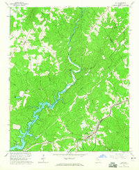
 1964 Leaf1965 Print · USGSNortheast Georgia in the mid-sixties reveals a rural landscape of mountain ridges and riverside mills along the Chattahoochee River. Genealogists and historians can locate family landmarks like Blue Creek Cem, the White Creek Sch, and the old Satterfield Store.4 unique versions available
 - 1964 Map of Lake Russell, 1965 Print
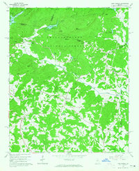 1964 Lake Russell1965 Print · USGSBanks County and the surrounding north Georgia highlands appear here in the mid-1960s as a landscape of timbered peaks and rural crossroads. Genealogists and local historians can locate family landmarks like Wofford Shoals Cem, Grady Sch, and Pinefield Crossroads.2 unique versions available
 - 1964 Map of Clarkesville, 1965 Print
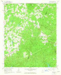
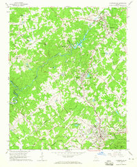 1964 Clarkesville1965 Print · USGSHabersham County during the mid-sixties reveals a landscape of growing towns and deep-rooted rural communities. Genealogists and local historians can trace family locations near Fairfield Ch, Mud Creek Sch, or the industrial Habersham Mills Lake.3 unique versions available
 - 1964 Map of Baldwin, 1965 Print
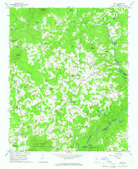
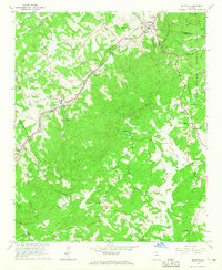 1964 Baldwin1965 Print · USGSNorth Georgia’s upland ridges and the CHATTAHOOCHEE NATIONAL FOREST are shown here as they appeared in the mid-1960s. Genealogists can trace family landmarks including Mud Creek Cemetery, the State Industrial Institute, and Liberty Hill Church.3 unique versions available
End of results
Showing maps 1-6 of 6
Top cities of Habersham County
- Cornelia historical maps
- Clarkesville historical maps
- Demorest historical maps
- Mount Airy historical maps
Frequently asked questions
- What are the different types of historical maps available for Habersham County?
- What is the oldest map of Habersham County?
- Where can I purchase historical maps of Habersham County for my home or office?
- Where can I download high-res historical maps of Habersham County?
- Are there historical topographic maps available for Habersham County?
- Is there historical aerial imagery available for Habersham County?
- Where are historical maps of Habersham County sourced from?