1940s Maps of Harris County, Georgia
Explore 2 historic maps of Harris County from the 1940s. These maps offer a rare glimpse into what life looked like during the 1940s — showing old roads, neighborhoods, homes, and landmarks that have changed or disappeared over time.
Whether you're researching your family's past, planning a metal detecting trip, or studying how Harris County's landscape evolved across the 1940s, these high-resolution maps are a powerful tool for exploring the history of this region.
- Focus on a specific era: All maps on this page are from the 1940s, giving you a focused view of this time period.
- See what’s changed: Compare century-old streets, trails, and buildings to today's modern landscape using overlays and satellite layers.
- Research with precision: Use these maps for genealogy, historical research, land use analysis, or educational projects.
- View, download, or print: Maps are fully viewable online in high resolution, and can be downloaded or printed for your own records.
Start exploring Harris County's history through authentic maps from the 1940s. This is your window into the past.
Harris County, GA maps
(2)- 1949 Map of Midland
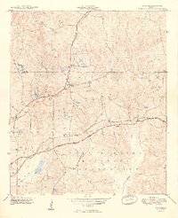 1949 Midland1949 Print · USGSMuscogee and Harris Counties appear here just after the war, showing the expansion of the Fort Benning Military Reservation. Researchers can trace the Southern rail lines connecting Midland and Schatulga.2 unique versions available
 - 1949 Map of Upatoi
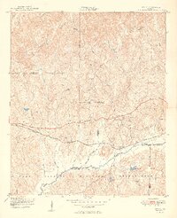 1949 Upatoi1949 Print · USGSThe Fort Benning boundary and the Central of Georgia railroad define this corner of Georgia in the late forties. Researchers can trace family landmarks like Mt Carmel Church and the rural settlements at Upatoi and Box Springs.2 unique versions available
End of results
Showing maps 1-2 of 2
Top cities of Harris County
- Pine Mountain historical maps
- Waverly Hall historical maps
- Hamilton historical maps
- Shiloh historical maps
Frequently asked questions
- What are the different types of historical maps available for Harris County?
- What is the oldest map of Harris County?
- Where can I purchase historical maps of Harris County for my home or office?
- Where can I download high-res historical maps of Harris County?
- Are there historical topographic maps available for Harris County?
- Is there historical aerial imagery available for Harris County?
- Where are historical maps of Harris County sourced from?