1960s Maps of Harris County, Georgia
Explore 7 historic maps of Harris County from the 1960s. These maps offer a rare glimpse into what life looked like during the 1960s — showing old roads, neighborhoods, homes, and landmarks that have changed or disappeared over time.
Whether you're researching your family's past, planning a metal detecting trip, or studying how Harris County's landscape evolved across the 1960s, these high-resolution maps are a powerful tool for exploring the history of this region.
- Focus on a specific era: All maps on this page are from the 1960s, giving you a focused view of this time period.
- See what’s changed: Compare century-old streets, trails, and buildings to today's modern landscape using overlays and satellite layers.
- Research with precision: Use these maps for genealogy, historical research, land use analysis, or educational projects.
- View, download, or print: Maps are fully viewable online in high resolution, and can be downloaded or printed for your own records.
Start exploring Harris County's history through authentic maps from the 1960s. This is your window into the past.
Harris County, GA maps
(7)- 1964 Map of Whitesville, 1965 Print
 1964 Whitesville1965 Print · USGSThe Georgia-Alabama border along the Chattahoochee River comes to life in the mid-1960s. Researchers can trace rural lineages through family landmarks like Billingslea Cem, Jones Crossroads, and Flat Shoal Ch.3 unique versions available
 - 1964 Map of Lanett South, 1966 Print
 1964 Lanett South1966 Print · USGSThe industrial corridor of the Chattahoochee Valley comes alive here in the mid-1960s, showing the tight-knit mill towns and rail networks of eastern Alabama. Researchers can trace the legacy of local families through Oak Wood Cem, Huguley Cem, and numerous country churches like Greenwood Ch.4 unique versions available
 - 1964 Map of Pine Mountain, 1966 Print
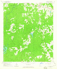
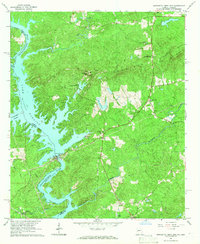
 1964 Pine Mountain1966 Print · USGSHarris County and the ridges of the Pine Mountain range were transitioning into a major recreational corridor in the mid-sixties. Genealogists and local historians can trace the foundations of Pine Mountain Valley, locate the Whitehead Cemetery, and explore the early layout of Callaway Gardens.
 - 1964 Map of Pine Mountain SW, 1966 Print
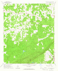 1964 Pine Mountain SW1966 Print · USGSHarris County in the mid-sixties reveals a landscape of ridge-top lookouts and deep-seated rural traditions as the timber and rail economy thrived. Researchers can trace family sites at Old Hopewell Cem, visit Smiths Crossroads, or locate the historic Carver High Sch.2 unique versions available
 - 1965 Map of Bartletts Ferry Dam, 1966 Print
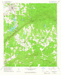
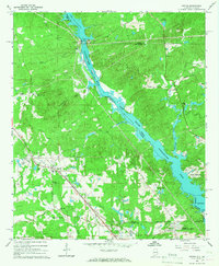
 1965 Bartletts Ferry Dam1966 Print · USGSThe Georgia-Alabama borderlands in the mid-1960s are defined by the rising waters of the Chattahoochee River and the ridgeline of Pine Mountain. Genealogists and historians can trace community landmarks like Antioch Ch (Cem), the Mountain Hill Sch, and the Bartletts Ferry Dam.2 unique versions available
 - 1965 Map of Beulah, 1967 Print
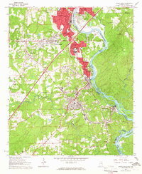
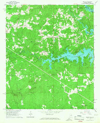 1965 Beulah1967 Print · USGSLee and Chambers counties meet along the Chattahoochee in the mid-1960s, showing a landscape shaped by the waters of Lake Harding. Researchers can locate a historic Covered Bridge, early rural churches like Liberty Ch, and the small community of Mechanicsville.2 unique versions available
 - 1965 Map of Smiths, 1967 Print
 1965 Smiths1967 Print · USGSThe Alabama-Georgia borderlands along the Chattahoochee River are captured here in the mid-sixties as hydroelectric dams reshaped the valley. Trace the growth of Smiths and Monterey Heights or locate family sites at Mt Zion Cem and Union Grove Ch.3 unique versions available
End of results
Showing maps 1-7 of 7
Top cities of Harris County
- Pine Mountain historical maps
- Waverly Hall historical maps
- Hamilton historical maps
- Shiloh historical maps
Frequently asked questions
- What are the different types of historical maps available for Harris County?
- What is the oldest map of Harris County?
- Where can I purchase historical maps of Harris County for my home or office?
- Where can I download high-res historical maps of Harris County?
- Are there historical topographic maps available for Harris County?
- Is there historical aerial imagery available for Harris County?
- Where are historical maps of Harris County sourced from?