1900s (20th Century) Maps of Ephesus, Georgia
Explore 8 historic maps of Ephesus from the 1900s (20th Century). These maps offer a rare glimpse into what life looked like during the 1900s — showing old roads, neighborhoods, homes, and landmarks that have changed or disappeared over time.
Whether you're researching your family's past, planning a metal detecting trip, or studying how Ephesus's landscape evolved across the 1900s, these high-resolution maps are a powerful tool for exploring the history of this region.
- Focus on a specific era: All maps on this page are from the 1900s, giving you a focused view of this time period.
- See what’s changed: Compare century-old streets, trails, and buildings to today's modern landscape using overlays and satellite layers.
- Research with precision: Use these maps for genealogy, historical research, land use analysis, or educational projects.
- View, download, or print: Maps are fully viewable online in high resolution, and can be downloaded or printed for your own records.
Start exploring Ephesus's history through authentic maps from the 1900s. This is your window into the past.
Ephesus, GA maps
(8)- 1902 Map of Wedowee
 1902 Wedowee1902 Print · USGSThe Alabama and Georgia state line bisects this turn-of-the-century landscape of river crossings and hill-country settlements. Genealogists can trace early homesteads and commerce at Philpots Ferry, the Copper Mine, or the town of Wedowee.3 unique versions available
 - 1953 Map of Atlanta, 1965 Print
 1953 Atlanta1965 Print · USGSThe growing Atlanta metro and the industrial corridors of Eastern Alabama are captured here during the mid-century transition. Researchers can trace the rail-to-road shift through hubs like Anniston and La Grange or locate sites within Fort McClellan.2 unique versions available
 - 1957 Map of Atlanta
 1957 Atlanta1957 Print · USGSAtlanta and the Alabama borderlands appear here in the mid-fifties, capturing the region's post-war suburban and industrial transition. Trace the development of early transport hubs and military sites like Fort McPherson, Anniston, and the Kennesaw Mountain National Battlefield Park.
 - 1958 Map of Atlanta
 1958 Atlanta1958 Print · USGSMid-century Georgia and Alabama are shown in this regional study of the corridor between the Chattahoochee River and the Appalachian foothills. Local historians can trace the development of suburban Atlanta alongside vital landmarks like Stone Mountain, Dobbins AFB, and the Seaboard Air Line rail routes.
 - 1964 Map of Roopville, 1966 Print
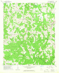 1964 Roopville1966 Print · USGSIn the mid-1960s, the borderlands between Carroll and Heard County remained a tapestry of small church-centered communities and winding creeks. Local historians can trace the foundations of Roopville and Ephesus, or locate landmarks like Unity Cem Ch and the Lookout Tower.2 unique versions available
 - 1969 Map of Graham, 1973 Print
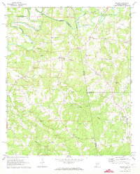 1969 Graham1973 Print · USGSRandolph and Cleburne Counties are captured here in the late sixties as traditional agricultural communities along the Georgia border. Researchers can trace family roots at numerous rural sites like Graham, the Old Shiloh Church, and Sewell.3 unique versions available
 - 1975 Map of Graham, 1977 Print
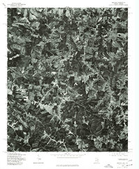 1975 Graham1977 Print · USGSThe Alabama and Georgia borderlands appear in striking photographic detail in the mid-seventies, showing the rural landscape surrounding the Graham community. Genealogists and local historians can trace exact farmstead locations near Ephesus and the banks of the Little Tallapoosa River.
 - 1978 Map of La Grange, 1980 Print
 1978 La Grange1980 Print · USGSThe Alabama-Georgia borderlands are captured here in the late seventies, just as the newly formed West Point Lake reshaped the eastern landscape. Local historians can trace the Seaboard Coast Line rail corridor through hubs like Roanoke, Ashland, and Lineville.
End of results
Showing maps 1-8 of 8
Top cities near Ephesus
- Carrollton historical maps
- Roanoke historical maps
- Bowdon historical maps
- Mount Zion historical maps
- Franklin historical maps
- Wedowee historical maps
See more
Frequently asked questions
- What are the different types of historical maps available for Ephesus?
- What is the oldest map of Ephesus?
- Where can I purchase historical maps of Ephesus for my home or office?
- Where can I download high-res historical maps of Ephesus?
- Are there historical topographic maps available for Ephesus?
- Is there historical aerial imagery available for Ephesus?
- Where are historical maps of Ephesus sourced from?