1970s Maps of Warner Robins, Georgia
Explore 5 historic maps of Warner Robins from the 1970s. These maps offer a rare glimpse into what life looked like during the 1970s — showing old roads, neighborhoods, homes, and landmarks that have changed or disappeared over time.
Whether you're researching your family's past, planning a metal detecting trip, or studying how Warner Robins's landscape evolved across the 1970s, these high-resolution maps are a powerful tool for exploring the history of this region.
- Focus on a specific era: All maps on this page are from the 1970s, giving you a focused view of this time period.
- See what’s changed: Compare century-old streets, trails, and buildings to today's modern landscape using overlays and satellite layers.
- Research with precision: Use these maps for genealogy, historical research, land use analysis, or educational projects.
- View, download, or print: Maps are fully viewable online in high resolution, and can be downloaded or printed for your own records.
Start exploring Warner Robins's history through authentic maps from the 1970s. This is your window into the past.
Warner Robins, GA maps
(5)- 1973 Map of Warner Robins NE, 1977 Print
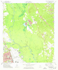 1973 Warner Robins NE1977 Print · USGSWarner Robins and the Ocmulgee River basin are captured here in the early seventies during a period of significant military and industrial activity. Researchers can trace family sites like Bond Cem and Bethlehem Ch or locate industrial landmarks like the Huber Tailings Pond.2 unique versions available
 - 1973 Map of Warner Robins SE, 1977 Print
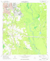 1973 Warner Robins SE1977 Print · USGSHouston County at the start of the 1970s shows the expansion of Warner Robins alongside the vast installation of Robins Air Force Base. Researchers can locate several schools and churches like Sacred Heart Sch, or trace the rural landscape around Bonaire and the Ocmulgee River.2 unique versions available
 - 1973 Map of Warner Robins SW, 1977 Print
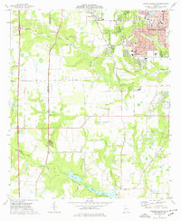 1973 Warner Robins SW1977 Print · USGSWarner Robins and Centerville were undergoing rapid growth in the 1970s as suburban subdivisions reached toward the Peach County line. Genealogists and historians can locate family landmarks like Leverett Cem, Andrew Chapel, and the Warner Robins Drag Way.3 unique versions available
 - 1973 Map of Warner Robins NW, 1977 Print
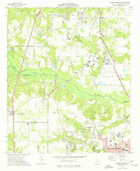 1973 Warner Robins NW1977 Print · USGSMid-century central Georgia comes alive in this survey of the railroad and racing corridor between Macon and Warner Robins. Genealogists and local historians can trace family-named sites like Skipperton and Walden or locate historic congregations such as New Elim Ch and Oak Grove Ch.3 unique versions available
 - 1978 Map of Macon, 1980 Print
 1978 Macon1980 Print · USGSCentral Georgia during the late seventies reveals a landscape shaped by military expansion and clay mining. Genealogists and local historians can trace the development of Warner Robins, the grounds of Wesleyan College, and the rural surroundings of Griswoldville.2 unique versions available
End of results
Showing maps 1-5 of 5
Top cities near Warner Robins
- Macon historical maps
- Perry historical maps
- Fort Valley historical maps
- Centerville historical maps
- Byron historical maps
- Robins Air Force Base historical maps
Top neighborhoods of Warner Robins
- Honey Ridge Plantation historical maps
- Richmond Hill historical maps
- Danes Meadow historical maps
- Wilshire Mobile Home Park historical maps
- Echo Glen historical maps
- Georgian Walk historical maps
See more
Frequently asked questions
- What are the different types of historical maps available for Warner Robins?
- What is the oldest map of Warner Robins?
- Where can I purchase historical maps of Warner Robins for my home or office?
- Where can I download high-res historical maps of Warner Robins?
- Are there historical topographic maps available for Warner Robins?
- Is there historical aerial imagery available for Warner Robins?
- Where are historical maps of Warner Robins sourced from?