
1973 Map of Warner Robins NE
USGS Topo · Published 1977About this map
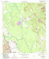
Warner Robins Air Force Base dominates the southern landscape of this 1973 survey, showing the extensive airfield and military infrastructure adjacent to the growing city of Warner Robins. The terrain is defined by the meandering Ocmulgee River and its vast wetlands, including Bond Swamp and Denson Marsh. This river corridor serves as a significant county boundary, separating Bibb, Twiggs, and Houston counties. Industrial activity is evident through numerous extraction sites like the Claypit and Sandpit operations near Huber, including a large Tailings Pond. Local genealogy is well-preserved through several rural landmarks, such as Chance Hill Ch, Friendship Ch, and Lar Grove Ch Cem. The Southern railroad line cuts through the area, facilitating the transport of materials from the pits to the larger regional networks during this era of mid-century industrial and military expansion.
Find a feature on this map
46 named features on this map. Tap any name to fly to it.
Don’t see what you’re looking for? This feature index may not catch every label — zoom into the map to look around manually.
Map Details
Editions of this 1973 Warner Robins NE Map
2 editions found
Other maps of this area

1956 · Gordon
USGS Topo · 1:62,500

1956 · Warner Robins
USGS Topo · 1:62,500

1956 · Jeffersonville
USGS Topo · 1:62,500

1956 · Macon West
USGS Topo · 1:24,000

1956 · Macon East
USGS Topo · 1:24,000

1956 · Macon
USGS Topo · 1:62,500

1957 · Macon
USGS Topo · 1:250,000

1958 · Macon
USGS Topo · 1:250,000

1964 · Macon
USGS Topo · 1:250,000

1973 · Tarversville
USGS Topo · 1:24,000