
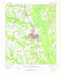
1956 Map of Warner Robins
USGS Topo · Published 1957About this map
Warner Robins dominates the center of this mid-1950s survey, showing its rapid growth during the Cold War era. The city’s footprint is inextricably linked to the massive US Military Reservation and Robins Air Force Base to its east, as well as the US Naval Reservation Supply Center near Byron. This period captures a landscape in transition, where established rural communities and landmarks like Feagin Mill on Sandy Run sit alongside new urban expansion. Local genealogy and history are well-preserved through numerous small churches and schools that dotted the countryside, such as Beulah Ch, Jerusalem Sch, and Evergreen Ch. To the north, the Macon Municipal Airport and Radio Range Station (MCA) highlight the region's developing aviation infrastructure, while the Ocmulgee River swamp and the Central of Georgia railroad define the traditional transport corridors.
Find a feature on this map
70 named features on this map. Tap any name to fly to it.
Don’t see what you’re looking for? This feature index may not catch every label — zoom into the map to look around manually.
Map Details
Editions of this 1956 Warner Robins Map
2 editions found
Other maps of this area

1956 · Fort Valley
USGS Topo · 1:62,500

1956 · Cochran
USGS Topo · 1:62,500

1956 · Bolingbroke
USGS Topo · 1:62,500

1956 · Perry
USGS Topo · 1:62,500

1956 · Gordon
USGS Topo · 1:62,500

1956 · Jeffersonville
USGS Topo · 1:62,500

1956 · Macon West
USGS Topo · 1:24,000

1956 · Macon East
USGS Topo · 1:24,000

1956 · Macon
USGS Topo · 1:62,500

1957 · Macon
USGS Topo · 1:250,000