1956 Map of Warner Robins
USGS Topo · Published 1966About this map
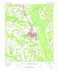
Warner Robins serves as the focal point of this mid-century survey, dominated by the massive footprint of the Robins Air Force Base and the adjacent U S Naval Reservation Supply Center. This era represents a period of significant military and industrial importance for Houston County, which is reflected in the dense concentration of housing near the base. Beyond the military zones, the landscape retains its rural character, shaped by the Ocmulgee River and its extensive floodplains. Smaller settlements like Byron, Centerville, and Bonaire are connected by the Central of Georgia and Southern railroads. Local landmarks such as Feagin Mill on Sandy Run, numerous country churches like Andrews Chapel, and several local schools including Smyrna Sch and Oak Grove Sch provide a detailed view of the community's social and economic structure during this post-war expansion.
Find a feature on this map
79 named features on this map. Tap any name to fly to it.
Don’t see what you’re looking for? This feature index may not catch every label — zoom into the map to look around manually.
Map Details
Editions of this 1956 Warner Robins Map
2 editions found

Historical Maps of Macon Through Time
1 maps found