
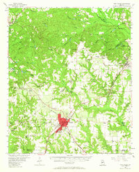
1956 Map of Fort Valley
USGS Topo · Published 1957About this map
Fort Valley serves as the bustling hub of this mid-century Georgia landscape, where the Central of Georgia, Southern, and Georgia railroads converge at the town center. The map reveals a dense network of rural life, anchored by small settlements like Byron, Powersville, and Knoxville. Agricultural and early industrial patterns are evident in landmarks like Taylors Mill on Mossy Creek and the Sand Pits near Gaillard. Numerous country churches and schools, such as Lizzie Chapel, Mt Zion Ch, and the Mathews Sch, indicate the social fabric of Peach and Crawford counties during this era. Public infrastructure is well-defined, ranging from the County Hospital in the county seat to the Radio Station (WFPM) located just outside the city limits. The terrain is marked by distinctive local landmarks like Society Hill and the recreational grounds of Camp Benjamin Hawkins.
Find a feature on this map
73 named features on this map. Tap any name to fly to it.
Don’t see what you’re looking for? This feature index may not catch every label — zoom into the map to look around manually.
Map Details
Editions of this 1956 Fort Valley Map
2 editions found
Other maps of this area

1951 · Yatesville
USGS Topo · 1:62,500

1955 · Phenix City
USGS Topo · 1:250,000

1956 · Bolingbroke
USGS Topo · 1:62,500

1956 · Perry
USGS Topo · 1:62,500

1956 · Warner Robins
USGS Topo · 1:62,500

1956 · Macon West
USGS Topo · 1:24,000

1956 · Macon
USGS Topo · 1:62,500

1957 · Phenix City
USGS Topo · 1:250,000

1957 · Macon
USGS Topo · 1:250,000

1958 · Macon
USGS Topo · 1:250,000