1970s Maps of Jasper County, Georgia
Explore 6 historic maps of Jasper County from the 1970s. These maps offer a rare glimpse into what life looked like during the 1970s — showing old roads, neighborhoods, homes, and landmarks that have changed or disappeared over time.
Whether you're researching your family's past, planning a metal detecting trip, or studying how Jasper County's landscape evolved across the 1970s, these high-resolution maps are a powerful tool for exploring the history of this region.
- Focus on a specific era: All maps on this page are from the 1970s, giving you a focused view of this time period.
- See what’s changed: Compare century-old streets, trails, and buildings to today's modern landscape using overlays and satellite layers.
- Research with precision: Use these maps for genealogy, historical research, land use analysis, or educational projects.
- View, download, or print: Maps are fully viewable online in high resolution, and can be downloaded or printed for your own records.
Start exploring Jasper County's history through authentic maps from the 1970s. This is your window into the past.
Jasper County, GA maps
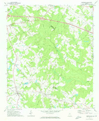
(6)- 1972 Map of Monticello, 1974 Print
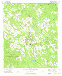 1972 Monticello1974 Print · USGSMonticello and the surrounding Jasper County landscape are captured here in the early seventies, showing a classic Georgia rail town before modern expansion. Researchers can trace family roots at West View Cem, locate rural congregations like Talmadge Ch, or follow the path of the Georgia Central Railroad.2 unique versions available
 - 1972 Map of Shady Dale, 1974 Print
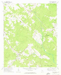 1972 Shady Dale1974 Print · USGSJasper and Morgan County crossroads are preserved here during the early seventies, centered on the rail-based growth of Shady Dale and Machen. Researchers can trace old family sites and local landmarks like Pleasant Grove Ch and the Central of Georgia rail line.2 unique versions available
 - 1972 Map of Smithboro, 1974 Print
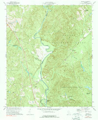
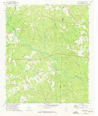 1972 Smithboro1974 Print · USGSThe rural landscape of Jasper and Putnam Counties in the 1970s is defined by the dense woods of the Oconee National Forest. Researchers can trace old transportation routes and local landmarks including Reids Chapel, the Central of Georgia rail line, and the namesake settlement of Smithboro.2 unique versions available
 - 1972 Map of Farrar, 1974 Print
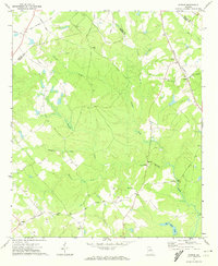 1972 Farrar1974 Print · USGSJasper and Newton counties are captured here in the early 1970s, showing a rural landscape of winding creeks and country crossroads. Genealogists can trace family landmarks like Pitts Chapel, Shiloh Ch, and the small community of Farrar along the Central of Georgia rail line.2 unique versions available
 - 1972 Map of Mansfield, 1974 Print
 1972 Mansfield1974 Print · USGSNewton County in the early seventies remains a landscape of rail-connected towns and country churches. Genealogists can trace family names and old landmarks across the Central of Georgia line between Mansfield and the historic Brick Store settlement.2 unique versions available
 - 1973 Map of Berner, 1975 Print
 1973 Berner1975 Print · USGSCentral Georgia's river-cut timberlands are captured here in the early seventies, showing the rural communities of Jasper and Butts counties. Genealogists and historians can trace the Southern railroad corridor through Berner and locate country congregations like Ward Ch.2 unique versions available
End of results
Showing maps 1-6 of 6
Top cities of Jasper County
Frequently asked questions
- What are the different types of historical maps available for Jasper County?
- What is the oldest map of Jasper County?
- Where can I purchase historical maps of Jasper County for my home or office?
- Where can I download high-res historical maps of Jasper County?
- Are there historical topographic maps available for Jasper County?
- Is there historical aerial imagery available for Jasper County?
- Where are historical maps of Jasper County sourced from?