1970s Maps of Shady Dale, Georgia
Explore 1 historic maps of Shady Dale from the 1970s. These maps offer a rare glimpse into what life looked like during the 1970s — showing old roads, neighborhoods, homes, and landmarks that have changed or disappeared over time.
Whether you're researching your family's past, planning a metal detecting trip, or studying how Shady Dale's landscape evolved across the 1970s, these high-resolution maps are a powerful tool for exploring the history of this region.
- Focus on a specific era: All maps on this page are from the 1970s, giving you a focused view of this time period.
- See what’s changed: Compare century-old streets, trails, and buildings to today's modern landscape using overlays and satellite layers.
- Research with precision: Use these maps for genealogy, historical research, land use analysis, or educational projects.
- View, download, or print: Maps are fully viewable online in high resolution, and can be downloaded or printed for your own records.
Start exploring Shady Dale's history through authentic maps from the 1970s. This is your window into the past.
Shady Dale, GA maps
(1)- 1972 Map of Shady Dale, 1974 Print
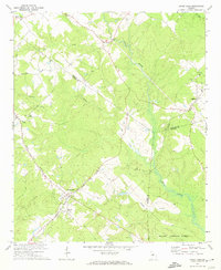 1972 Shady Dale1974 Print · USGSJasper and Morgan County crossroads are preserved here during the early seventies, centered on the rail-based growth of Shady Dale and Machen. Researchers can trace old family sites and local landmarks like Pleasant Grove Ch and the Central of Georgia rail line.2 unique versions available
End of results
Showing maps 1-1 of 1
Top cities near Shady Dale
- Covington historical maps
- Eatonton historical maps
- Social Circle historical maps
- Madison historical maps
- Monticello historical maps
- Rutledge historical maps
See more
Frequently asked questions
- What are the different types of historical maps available for Shady Dale?
- What is the oldest map of Shady Dale?
- Where can I purchase historical maps of Shady Dale for my home or office?
- Where can I download high-res historical maps of Shady Dale?
- Are there historical topographic maps available for Shady Dale?
- Is there historical aerial imagery available for Shady Dale?
- Where are historical maps of Shady Dale sourced from?