
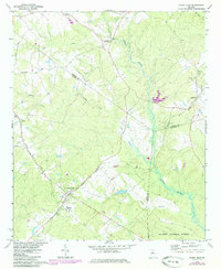
1972 Map of Shady Dale
USGS Topo · Published 1974About this map
The Central of Georgia railroad corridor serves as the primary artery for this region of the Piedmont, connecting the settlements of Shady Dale, Machen, and Godfrey. The map details a landscape of transitioning rural life in the early 1970s, where several cemeteries and country churches like Pleasant Grove Ch and Enon Ch anchor long-standing family communities. The convergence of the Jasper, Morgan, and Putnam county lines highlights the area's political geography, while the southeastern corner is defined by the managed woodlands of the Oconee National Forest. Waterways like the Little River and Turkey Creek dictate the local topography, with a small Landing Strip near Kelly suggesting the modernization of local transport and agriculture during this era. This survey provides a clear view of the rural crossroads and rail-side hamlets before the expansion of modern residential development.
Find a feature on this map
26 named features on this map. Tap any name to fly to it.
Don’t see what you’re looking for? This feature index may not catch every label — zoom into the map to look around manually.
Map Details
Editions of this 1972 Shady Dale Map
2 editions found
Other maps of this area

1896 · Monroe
USGS Topo · 1:125,000

1953 · Athens
USGS Topo · 1:250,000

1958 · Athens
USGS Topo · 1:250,000

1959 · Athens
USGS Topo · 1:250,000

1963 · Athens
USGS Topo · 1:250,000

1972 · Monticello
USGS Topo · 1:24,000

1972 · Eatonton
USGS Topo · 1:24,000
1972 · Smithboro
USGS Topo · 1:24,000

1972 · Rock Eagle Lake
USGS Topo · 1:24,000
1972 · Rutledge South
USGS Topo · 1:24,000