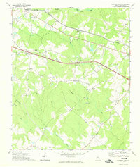
1972 Map of Rutledge South
USGS Topo · Published 1974About this map
Rutledge and the southern edge of Hard Labor State Park anchor this early 1970s survey of Morgan County. The landscape is defined by the headwaters and tributaries of Big Indian Creek and the Little River, where a network of rural settlements like Dorsey, Centennial, and Brownwood are linked by Georgia 12. The presence of numerous country churches, including Macedonia Ch, Mars Hill Ch, and Wallace Grove Ch, suggests the established community structure of the era. To the south, Clack Bridge crosses the river, while a Lookout Tower near Centennial and a Quarry west of Dickson point to the local forestry and industrial activity. This map captures the region's character just as modern highway infrastructure began to bisect the traditional agricultural and church-centered communities of central Georgia.
Find a feature on this map
29 named features on this map. Tap any name to fly to it.
Don’t see what you’re looking for? This feature index may not catch every label — zoom into the map to look around manually.
Map Details
Editions of this 1972 Rutledge South Map
2 editions found
Other maps of this area

1896 · Monroe
USGS Topo · 1:125,000

1953 · Athens
USGS Topo · 1:250,000

1958 · Athens
USGS Topo · 1:250,000

1959 · Athens
USGS Topo · 1:250,000

1963 · Athens
USGS Topo · 1:250,000

1971 · Rutledge North
USGS Topo · 1:24,000
1971 · Social Circle
USGS Topo · 1:24,000

1972 · Shady Dale
USGS Topo · 1:24,000

1972 · Apalachee
USGS Topo · 1:24,000

1972 · Rock Eagle Lake
USGS Topo · 1:24,000