1940s Maps of Jefferson County, Georgia
Explore 6 historic maps of Jefferson County from the 1940s. These maps offer a rare glimpse into what life looked like during the 1940s — showing old roads, neighborhoods, homes, and landmarks that have changed or disappeared over time.
Whether you're researching your family's past, planning a metal detecting trip, or studying how Jefferson County's landscape evolved across the 1940s, these high-resolution maps are a powerful tool for exploring the history of this region.
- Focus on a specific era: All maps on this page are from the 1940s, giving you a focused view of this time period.
- See what’s changed: Compare century-old streets, trails, and buildings to today's modern landscape using overlays and satellite layers.
- Research with precision: Use these maps for genealogy, historical research, land use analysis, or educational projects.
- View, download, or print: Maps are fully viewable online in high resolution, and can be downloaded or printed for your own records.
Start exploring Jefferson County's history through authentic maps from the 1940s. This is your window into the past.
Jefferson County, GA maps
(6)- 1948 Map of Hephzibah
 1948 Hephzibah1948 Print · USGSRichmond County and the Augusta suburbs are seen here during the late 1940s as military footprints like Camp Gordon began to reshape the landscape. Genealogists and local historians can locate dozens of country churches and rural cemeteries, from the Albion-Kaolin Chalk Mine to the Georgia Training School Farm.2 unique versions available
 - 1948 Map of Harlem
 1948 Harlem1948 Print · USGSEastern Georgia in the late forties shows the expansion of the Camp Gordon Military Reservation into a landscape of rural hamlets. Researchers can trace old family sites like Bynum Cemetery and vanished landmarks like Central School (Abandoned).2 unique versions available
 - 1948 Map of Stapleton
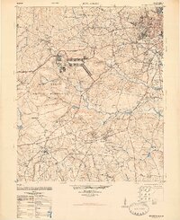
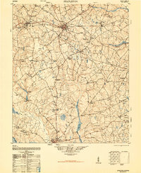 1948 Stapleton1948 Print · USGSJefferson County and the surrounding countryside appear in detail during the late 1940s, showing a landscape of rail junctions and rural homesteads. Genealogists and historians can trace family locations through sites like Ellis Plantation, Ponder Family Cemetery, and the old Wrens Station.2 unique versions available
 - 1948 Map of Gough
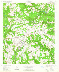
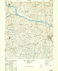 1948 Gough1948 Print · USGSMid-century Burke County is a landscape of rural schoolhouses and family-named mills as the post-war era began. Genealogists can trace family roots through sites like Boggs Academy, Noah's Ark Church & Cem, and Dyes Crossroads.2 unique versions available
 - 1948 Map of Blythe, 1964 Print
 1948 Blythe1964 Print · USGSBlythe and the surrounding Richmond County countryside appear here just after the war, showing a landscape of small family farms and rural schools. Researchers can trace local genealogy through sites like Doyle Grove Church and School, the Saxon Cemetery, and the Camp Gordon Military Reservation boundary.4 unique versions available
 - 1948 Map of Louisville, 1964 Print
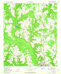 1948 Louisville1964 Print · USGSJefferson County in the late 1940s is shown here as a network of creek-side settlements and rural congregations. Genealogists can locate family landmarks like Bothwell Cemetery or community hubs such as Pioneer Church and School and Duhart Church.2 unique versions available
End of results
Showing maps 1-6 of 6
Top cities of Jefferson County
- Louisville historical maps
- Wadley historical maps
- Wrens historical maps
- Stapleton historical maps
- Bartow historical maps
- Avera historical maps
Frequently asked questions
- What are the different types of historical maps available for Jefferson County?
- What is the oldest map of Jefferson County?
- Where can I purchase historical maps of Jefferson County for my home or office?
- Where can I download high-res historical maps of Jefferson County?
- Are there historical topographic maps available for Jefferson County?
- Is there historical aerial imagery available for Jefferson County?
- Where are historical maps of Jefferson County sourced from?