1970s Maps of Louisville, Georgia
Explore 2 historic maps of Louisville from the 1970s. These maps offer a rare glimpse into what life looked like during the 1970s — showing old roads, neighborhoods, homes, and landmarks that have changed or disappeared over time.
Whether you're researching your family's past, planning a metal detecting trip, or studying how Louisville's landscape evolved across the 1970s, these high-resolution maps are a powerful tool for exploring the history of this region.
- Focus on a specific era: All maps on this page are from the 1970s, giving you a focused view of this time period.
- See what’s changed: Compare century-old streets, trails, and buildings to today's modern landscape using overlays and satellite layers.
- Research with precision: Use these maps for genealogy, historical research, land use analysis, or educational projects.
- View, download, or print: Maps are fully viewable online in high resolution, and can be downloaded or printed for your own records.
Start exploring Louisville's history through authentic maps from the 1970s. This is your window into the past.
Louisville, GA maps
(2)- 1973 Map of Louisville South, 1976 Print
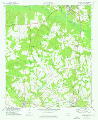 1973 Louisville South1976 Print · USGSJefferson County thrived as a rail and river hub in the early seventies, with the Central of Georgia linking small towns. Genealogists can locate family landmarks like Ebenezer Cemetery, Old Bethel Church, and Moxley.2 unique versions available
 - 1973 Map of Old Town, 1976 Print
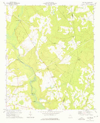 1973 Old Town1976 Print · USGSSettlements and river bends along the Ogeechee River defined this corner of Georgia in the early 1970s. Genealogists and historians can trace the locations of numerous rural churches like Mt Olive Ch and Union Bethel Ch, or locate the Old Railroad Grade near Old Town.
End of results
Showing maps 1-2 of 2
Top cities near Louisville
- Wadley historical maps
- Wrens historical maps
- Davisboro historical maps
- Midville historical maps
- Stapleton historical maps
- Bartow historical maps
See more
Frequently asked questions
- What are the different types of historical maps available for Louisville?
- What is the oldest map of Louisville?
- Where can I purchase historical maps of Louisville for my home or office?
- Where can I download high-res historical maps of Louisville?
- Are there historical topographic maps available for Louisville?
- Is there historical aerial imagery available for Louisville?
- Where are historical maps of Louisville sourced from?