1970s Maps of Lee County, Georgia
Explore 12 historic maps of Lee County from the 1970s. These maps offer a rare glimpse into what life looked like during the 1970s — showing old roads, neighborhoods, homes, and landmarks that have changed or disappeared over time.
Whether you're researching your family's past, planning a metal detecting trip, or studying how Lee County's landscape evolved across the 1970s, these high-resolution maps are a powerful tool for exploring the history of this region.
- Focus on a specific era: All maps on this page are from the 1970s, giving you a focused view of this time period.
- See what’s changed: Compare century-old streets, trails, and buildings to today's modern landscape using overlays and satellite layers.
- Research with precision: Use these maps for genealogy, historical research, land use analysis, or educational projects.
- View, download, or print: Maps are fully viewable online in high resolution, and can be downloaded or printed for your own records.
Start exploring Lee County's history through authentic maps from the 1970s. This is your window into the past.
Lee County, GA maps
(12)- 1973 Map of Sasser, 1974 Print
 1973 Sasser1974 Print · USGSTerrell and Lee Counties appear in the early 1970s as a landscape of rural settlements and rail-line hubs. Genealogists and historians can trace family roots through sites like Macedonia Ch, Huckby Cem, and the old rail stop at Sasser.2 unique versions available
 - 1973 Map of Pretoria, 1974 Print
 1973 Pretoria1974 Print · USGSDougherty County in the early seventies shows a landscape of rail-connected settlements and winding creek bottoms. Genealogists and local historians can trace family locations near Pretoria, Lockett Crossing, and rural landmarks like Mossy Grove Ch.2 unique versions available
 - 1973 Map of Bronwood, 1975 Print
 1973 Bronwood1975 Print · USGSBronwood and the Terrell County countryside are shown here in the early seventies, a landscape of family farms and rural churches. Genealogists can trace local landmarks like Bridges Crossroad, Greater Macedonia Ch, and the Old Church Cem.
 - 1973 Map of Albany NE, 1975 Print
 1973 Albany NE1975 Print · USGSLee and Worth counties are captured in the early 1970s, showing a landscape defined by the winding Flint River and a dense network of namesake ponds. You can trace family history at Thundering Springs Cem and Old Mt Horeb Cem, or locate landmarks like Old Piney Grove Ch.2 unique versions available
 - 1973 Map of Neyami, 1975 Print
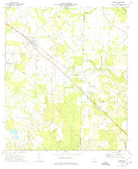
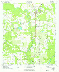
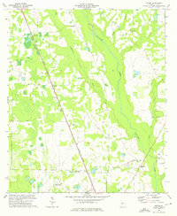 1973 Neyami1975 Print · USGSLee County, Georgia, is captured here in the early 1970s as an agricultural landscape shaped by the Central of Georgia railroad and the Muckalee Creek drainage. Researchers can trace rural settlement patterns through named locales like Starksville and Neyami, or locate family landmarks such as McAfee Ch and the Jordan Place.
 - 1973 Map of Leslie, 1975 Print
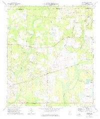
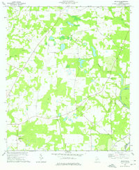
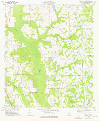
 1973 Leslie1975 Print · USGSSumter and Lee Counties come into focus in the early 1970s, showcasing a community built on agriculture and rail transport. Genealogists can trace family roots through numerous local landmarks like Union High School, Jackson Grove Church, and Mt Zion Cemetery.
 - 1973 Map of Leslie SE, 1976 Print
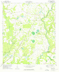
 1973 Leslie SE1976 Print · USGSLee and Worth counties meet along the river in the early 1970s, showing a landscape of small rural settlements and agricultural ties. Researchers can trace local heritage through sites like St Mathews Ch, Mossy Dell, and the community of Tarpley.2 unique versions available
 - 1973 Map of Smithville West, 1976 Print
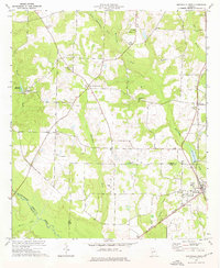 1973 Smithville West1976 Print · USGSThe agricultural plains of Sumter and Lee Counties are captured here in the early seventies, centered on the rail-side community of Smithville. Researchers can find numerous rural landmarks, from the Smithville Academy and Green Grove Sch to historic congregations at Hebron Ch and St Pauls Ch.
 - 1973 Map of Leesburg, 1976 Print
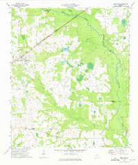
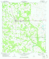
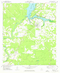
 1973 Leesburg1976 Print · USGSIn the early seventies, this Lee County area centered on the railroad crossing at Leesburg and the winding banks of Kinchafoonee Creek. Genealogists can trace rural landmarks from Byne Crossroads to historic sites like Palmyra Cem and Alpha Ch.2 unique versions available
 - 1973 Map of Smithville East, 1976 Print
 1973 Smithville East1976 Print · USGSSumter and Lee Counties in the early seventies reveal a landscape of deep creek bottoms and railroad corridors. Genealogists and historians can trace family roots through the Anthony Cem, Deldrich Cem, and Mt Pleasant Ch.2 unique versions available
 - 1977 Map of Cobb
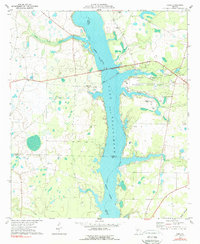 1977 Cobb1977 Print · USGSLake Blackshear and the Flint River shoreline define this South Georgia landscape during the 1970s. Researchers can trace rural church history at New Zion Ch and Springhill Ch or locate the old Seaboard Coast Line rail corridor.2 unique versions available
 - 1977 Map of Warwick
 1977 Warwick1977 Print · USGSIn the late 1970s, the area around Warwick was defined by the waters of the Flint River and Lake Blackshear. Genealogists and historians can trace local landmarks like Bethlehem Ch, Davis Mill, and the Georgia Northern rail line.
End of results
Showing maps 1-12 of 12
Top cities of Lee County
Frequently asked questions
- What are the different types of historical maps available for Lee County?
- What is the oldest map of Lee County?
- Where can I purchase historical maps of Lee County for my home or office?
- Where can I download high-res historical maps of Lee County?
- Are there historical topographic maps available for Lee County?
- Is there historical aerial imagery available for Lee County?
- Where are historical maps of Lee County sourced from?