
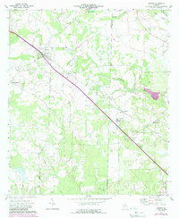
1973 Map of Sasser
USGS Topo · Published 1974About this map
The town of Sasser serves as the primary hub of this early 1970s landscape, situated at the intersection of the Seaboard Coast Line railroad and regional roadways. The surrounding terrain in Terrell and Lee Counties is defined by a network of rural settlements and agricultural areas, including Armena, Oakland, and Chickasawhatchee. Religious and family history is deeply embedded in the land, evidenced by several country churches and burial grounds such as Macedonia Ch, Mt Olive Ch, and the Huckby Cem.
Find a feature on this map
24 named features on this map. Tap any name to fly to it.
Don’t see what you’re looking for? This feature index may not catch every label — zoom into the map to look around manually.
Map Details
Editions of this 1973 Sasser Map
2 editions found
Other maps of this area

1953 · Dothan
USGS Topo · 1:250,000

1954 · Dothan
USGS Topo · 1:250,000

1955 · Dothan
USGS Topo · 1:250,000

1956 · Albany West
USGS Topo · 1:24,000

1956 · Sasser
USGS Topo · 1:62,500

1956 · Albany
USGS Topo · 1:62,500

1956 · Leslie
USGS Topo · 1:62,500

1973 · Chickasawhatchee
USGS Topo · 1:24,000

1973 · Pretoria
USGS Topo · 1:24,000

1973 · Dawson
USGS Topo · 1:24,000