
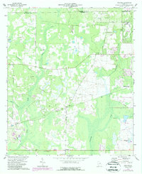
1973 Map of Pretoria
USGS Topo · Published 1974About this map
Pretoria and the surrounding Dougherty County landscape are defined by a complex network of wetlands and drainage basins in the early 1970s. The Central of Georgia railroad line cuts a straight path across the terrain, serving the small community of Walker and connecting the rural interior to broader markets. The geography is characterized by numerous slow-moving water bodies such as Kiokee Creek, Cooleewahee Creek, and Mud Creek, which are surrounded by extensive marshlands and topographic depressions like Percosin Creek.
Find a feature on this map
34 named features on this map. Tap any name to fly to it.
Don’t see what you’re looking for? This feature index may not catch every label — zoom into the map to look around manually.
Map Details
Editions of this 1973 Pretoria Map
2 editions found
Other maps of this area

1953 · Dothan
USGS Topo · 1:250,000

1954 · Dothan
USGS Topo · 1:250,000

1955 · Dothan
USGS Topo · 1:250,000

1956 · Albany West
USGS Topo · 1:24,000

1956 · Baconton
USGS Topo · 1:62,500

1956 · Newton
USGS Topo · 1:62,500

1956 · Sasser
USGS Topo · 1:62,500

1956 · Albany
USGS Topo · 1:62,500

1973 · Chickasawhatchee
USGS Topo · 1:24,000

1973 · Sasser
USGS Topo · 1:24,000