1920s Maps of Liberty County, Georgia
Explore 5 historic maps of Liberty County from the 1920s. These maps offer a rare glimpse into what life looked like during the 1920s — showing old roads, neighborhoods, homes, and landmarks that have changed or disappeared over time.
Whether you're researching your family's past, planning a metal detecting trip, or studying how Liberty County's landscape evolved across the 1920s, these high-resolution maps are a powerful tool for exploring the history of this region.
- Focus on a specific era: All maps on this page are from the 1920s, giving you a focused view of this time period.
- See what’s changed: Compare century-old streets, trails, and buildings to today's modern landscape using overlays and satellite layers.
- Research with precision: Use these maps for genealogy, historical research, land use analysis, or educational projects.
- View, download, or print: Maps are fully viewable online in high resolution, and can be downloaded or printed for your own records.
Start exploring Liberty County's history through authentic maps from the 1920s. This is your window into the past.
Liberty County, GA maps
(5)- 1920 Map of Pembroke
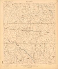 1920 Pembroke1920 Print · USGSGeorgia's coastal plain emerges in the years after the Great War, showing a network of rail lines and river landings. Genealogists can trace old family roots through Stevens Grove School, Beulah Church, and the settlement at Pembroke.3 unique versions available
 - 1920 Map of Glennville
 1920 Glennville1920 Print · USGSSoutheast Georgia in the years after the Great War shows a landscape of rail-connected timber towns and dozens of country schools. Genealogists can locate family landmarks like Vance School, trace the winding Altamaha River past Beards Bluff, or find old crossings like Flat Ford Bridge.3 unique versions available
 - 1920 Map of Sapelo River
 1920 Sapelo River1920 Print · USGSCoastal McIntosh and Liberty counties were a network of tidal rivers and timber-line railroads during the early twentieth century. Genealogists and historians can trace rail stops like Brewsters Siding, the winding course of the Julienton River, and the landing at Sutherland Bluff.
 - 1920 Map of Limerick, 1928 Print
 1920 Limerick1928 Print · USGSThe Georgia coast at the end of the Great War reveals a landscape shaped by tidal rivers and burgeoning timber railroads. Genealogists and local historians can trace family roots through the settlements of Limerick, Sunbury, and Riceboro, or locate the historic Midway Ch. and the coastal defenses of Fort Morris.
 - 1928 Map of St Catherines Island
 1928 St Catherines Island1928 Print · USGSCoastal Georgia's intricate barrier islands and marshes are captured here in the early twentieth century. Genealogists and historians can locate specific sites like Bakers House & Chimney, the Quarantine Stack, and Harris.
End of results
Showing maps 1-5 of 5
Top cities of Liberty County
- Hinesville historical maps
- Fort Stewart historical maps
- Walthourville historical maps
- Midway historical maps
- Riceboro historical maps
- Allenhurst historical maps
See more
Frequently asked questions
- What are the different types of historical maps available for Liberty County?
- What is the oldest map of Liberty County?
- Where can I purchase historical maps of Liberty County for my home or office?
- Where can I download high-res historical maps of Liberty County?
- Are there historical topographic maps available for Liberty County?
- Is there historical aerial imagery available for Liberty County?
- Where are historical maps of Liberty County sourced from?