1950s Maps of Liberty County, Georgia
Explore 24 historic maps of Liberty County from the 1950s. These maps offer a rare glimpse into what life looked like during the 1950s — showing old roads, neighborhoods, homes, and landmarks that have changed or disappeared over time.
Whether you're researching your family's past, planning a metal detecting trip, or studying how Liberty County's landscape evolved across the 1950s, these high-resolution maps are a powerful tool for exploring the history of this region.
- Focus on a specific era: All maps on this page are from the 1950s, giving you a focused view of this time period.
- See what’s changed: Compare century-old streets, trails, and buildings to today's modern landscape using overlays and satellite layers.
- Research with precision: Use these maps for genealogy, historical research, land use analysis, or educational projects.
- View, download, or print: Maps are fully viewable online in high resolution, and can be downloaded or printed for your own records.
Start exploring Liberty County's history through authentic maps from the 1950s. This is your window into the past.
Liberty County, GA maps
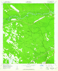
(24)- 1950 Map of Pembroke
 1950 Pembroke1950 Print · USGSIn mid-century Bryan County, the landscape around Pembroke was a mix of vital rail lines and expanding military boundaries. Genealogists and local historians can trace family locations near Beautiful Zion Cem, Ash Branch Church, and the rural Esla Sch.2 unique versions available
 - 1950 Map of Glennville
 1950 Glennville1950 Print · USGSGlennville and the surrounding Tattnall County timberlands are captured here at mid-century as the local economy balanced millpond industry with a growing military presence. Researchers can trace rural life through scattered landmarks like Smiley Crossroads, Donald, and the Rye Patch Sch.2 unique versions available
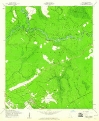
 - 1950 Map of Hinesville
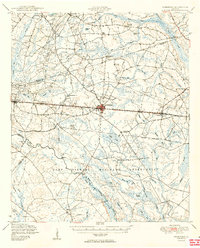
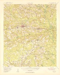
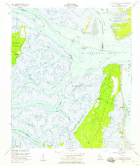
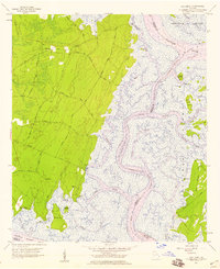
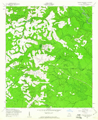
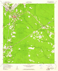
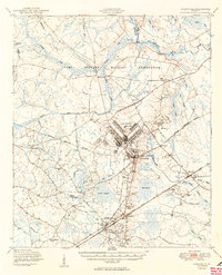 1950 Hinesville1950 Print · USGSLiberty County was undergoing a major transformation at mid-century as the military footprint grew around Hinesville. Genealogists and historians can trace the foundations of this change through landmarks like Terrells Millpond, Providence School, and the Cypress Slash Cem.2 unique versions available
 - 1950 Map of Limerick
 1950 Limerick1950 Print · USGSThe Georgia lowcountry at the mid-century mark shows a transition from coastal plantations to military and industrial expansion. Genealogists and historians can trace family roots through numerous sites like Dorchester Academy, Sunbury, and Scratchy Hall Cem.2 unique versions available
 - 1950 Map of Claxton
 1950 Claxton1950 Print · USGSMid-century Evans County centers on the thriving rail corridor connecting Claxton, Hagan, and Daisy during the height of the Seaboard Air Line era. Genealogists and historians can locate numerous rural landmarks like the Ennis Branch School, Sikes Chapel, and the vast Camp Stewart Military Reservation.2 unique versions available
 - 1954 Map of St Catherines Sound, 1958 Print
 1954 St Catherines Sound1958 Print · USGSCoastal Georgia's intricate salt marshes and barrier islands are captured in the mid-1950s, showing a landscape defined by tidal rivers and the Intracostal Waterway. You can trace old landing sites and local infrastructure like the Yellow Bluff Fishing Camp, Youmans Landing Field, and several island Artesian Wells.2 unique versions available
 - 1954 Map of Sapelo Sound, 1959 Print
 1954 Sapelo Sound1959 Print · USGSThe Georgia coast in the mid-fifties reveals an intricate network of sea islands and tidal marshes before modern development altered the shoreline. Genealogists and historians can trace family-named landmarks and remote artesian wells across Sapelo Island, Blackbeard Island, and Wahoo Island.3 unique versions available
 - 1954 Map of Seabrook, 1959 Print
 1954 Seabrook1959 Print · USGSCoastal Liberty County in the mid-1950s is a landscape of tidal rivers and historic landings at the edge of the Atlantic. Genealogists and historians can trace the foundations of Sunbury, locate the Lebanon Cem, and study the layout of the Harris Neck Airfield.2 unique versions available
 - 1955 Map of Riceboro, 1959 Print
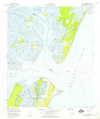
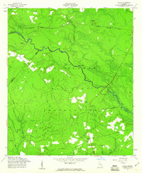
 1955 Riceboro1959 Print · USGSCoastal Georgia in the mid-fifties is defined here by the intersection of the Seaboard Air Line Railroad and the vast marshlands of Liberty and McIntosh Counties. Researchers can locate community centers like Riceboro, the First African Ch, and long-standing family landmarks such as Pando Cem.2 unique versions available
 - 1956 Map of Brunswick, 1968 Print
 1956 Brunswick1968 Print · USGSThe Georgia coast in the mid-twentieth century is a wild expanse of barrier islands and massive river deltas. You can trace the development of the maritime economy and military presence at Brunswick, or locate historic sites like Fort Frederica National Monument and Harris Neck National Wildlife Refuge.2 unique versions available
 - 1957 Map of Oak Level, 1959 Print
 1957 Oak Level1959 Print · USGSThe Georgia coastline near the Ogeechee and Medway rivers is shown here during the late fifties, capturing a landscape of tidal marshes and maritime forests. Genealogists and local historians can trace family-named sites like Fancy Hall, Lincoln Landing, and the Kilkenny Club.2 unique versions available
 - 1957 Map of Savannah, 1967 Print
 1957 Savannah1967 Print · USGSThe Lowcountry and Georgia coastal plain are shown here in the late fifties, prior to modern expansion. Researchers can trace the rail-and-river economy through the Central of Georgia lines and the Ogeechee River wetlands.4 unique versions available
 - 1958 Map of Glennville NE, 1961 Print
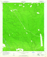
 1958 Glennville NE1961 Print · USGSCoastal Georgia's rural landscape is seen here during the late 1950s as military boundaries reshaped the backcountry of Long and Liberty Counties. Genealogists can trace several vanished church sites and cemeteries including Poplar Head Cem, Smith Chapel Cem, and New Bethel Ch.2 unique versions available
 - 1958 Map of Taylors Creek, 1961 Print
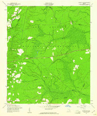
 1958 Taylors Creek1961 Print · USGSLiberty and Long County terrain is documented here in the late fifties as the military expanded its footprint. Genealogists can trace family burial grounds like Todd-Ray Cem and Taylors Creek Cem or follow the path of an Old Railroad Grade.3 unique versions available
 - 1958 Map of Walthourville, 1961 Print
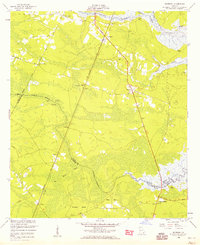
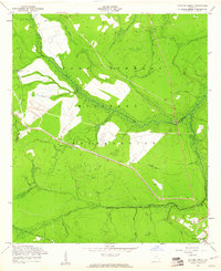
 1958 Walthourville1961 Print · USGSLiberty and Long Counties in the late fifties show the transition from rural farming communities to military land use. Genealogists and historians can locate old rural landmarks like Elim Ch, Wells Cem, and the waters of Terrells Millpond.2 unique versions available
 - 1958 Map of Limerick NW, 1961 Print
 1958 Limerick NW1961 Print · USGSThe Bryan and Liberty County line in the late fifties shows a landscape transitioning between rural life and military expansion. Genealogists can locate family landmarks like Briggs Cem or Dixie Daniel Sch along the Atlantic Coast Line corridor.3 unique versions available
 - 1958 Map of Trinity, 1961 Print
 1958 Trinity1961 Print · USGSFort Stewart and its environs are captured in the late fifties as the military landscape integrated former coastal plain settlements. Researchers can trace the legacy of the Trinity (Site), locate the Thomas Hill Cem, or follow the winding Canoochee River.3 unique versions available
 - 1958 Map of Letford, 1961 Print
 1958 Letford1961 Print · USGSBryan County was undergoing significant transformation in the late fifties as military expansion integrated local lands. Researchers can trace the remnants of earlier communities through Letford (Site), the Old Railroad Grade, and rural landmarks like Beulah Ch.3 unique versions available
 - 1958 Map of Limerick SE, 1961 Print
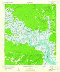 1958 Limerick SE1961 Print · USGSThe Georgia coast near Sunbury was a network of tidal rivers and rail sidings in the late fifties. You can locate family landmarks like the George Washington Carver Sch, the Fort Morris (Site), and Old Dorchester Cem among the marshlands.2 unique versions available
 - 1958 Map of Glissons Millpond, 1961 Print
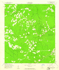
 1958 Glissons Millpond1961 Print · USGSCoastal Georgia in the late fifties shows a rural landscape transitioning into the Fort Stewart Military Reservation. Researchers can locate family burial sites at Barnard Cem or trace the remnant of an Old Railroad Grade near Camp Oliver.3 unique versions available
 - 1958 Map of Willie, 1961 Print
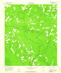
 1958 Willie1961 Print · USGSLiberty County was undergoing a major transformation in the late fifties as military expansion reshaped the rural landscape. Genealogists and historians can locate the former Willie settlement and trace ancestral roots at Jerusalem Cem or Salem Cem.3 unique versions available
 - 1958 Map of Dorchester, 1961 Print
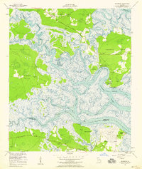
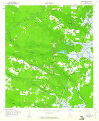 1958 Dorchester1961 Print · USGSCoastal Georgia in the late fifties was a landscape of dense swamps and rail-side settlements. Genealogists can trace family roots through numerous local landmarks like Liberty County High Sch, Midway, and Beech Hill Ch.3 unique versions available
 - 1958 Map of Glennville SE, 1961 Print
 1958 Glennville SE1961 Print · USGSCoastal Georgia's piney woods and wetlands are captured here in the late fifties, showing a landscape defined by creeks and timber infrastructure. Researchers can trace the Old Railroad Grade and locate rural landmarks like Smiley Crossroads and Rye Patch Ch.2 unique versions available
 - 1958 Map of Hinesville, 1961 Print
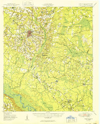
 1958 Hinesville1961 Print · USGSGeorgia's coastal plain south of Fort Stewart comes into focus in the late fifties, showing the area's transition between military expansion and deep-rooted rural settlements. Genealogists and historians can trace local family landmarks like Cypress Slash Cem, Walthourville, and Taylor Creek Ch.3 unique versions available
End of results
Showing maps 1-24 of 24
Top cities of Liberty County
- Hinesville historical maps
- Fort Stewart historical maps
- Walthourville historical maps
- Midway historical maps
- Riceboro historical maps
- Allenhurst historical maps
See more
Frequently asked questions
- What are the different types of historical maps available for Liberty County?
- What is the oldest map of Liberty County?
- Where can I purchase historical maps of Liberty County for my home or office?
- Where can I download high-res historical maps of Liberty County?
- Are there historical topographic maps available for Liberty County?
- Is there historical aerial imagery available for Liberty County?
- Where are historical maps of Liberty County sourced from?