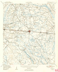
1950 Map of Pembroke
USGS Topo · Published 1950About this map
The town of Pembroke serves as the central hub of this South Georgia landscape, situated at a major crossroads and positioned along the Seaboard Air Line railroad. The surrounding terrain is characterized by a dense network of swampy bays and branches, including Mill Creek Bay and Cypress Bay, which dictated the early settlement patterns of Bryan and Bulloch counties. The southern portion of the sheet is dominated by the Camp Stewart Military Reservation, its boundary cutting through the rural landscape just south of Reka and Lanier. This 1950 edition reveals a community deeply rooted in its local institutions, evidenced by the numerous country churches and family-named cemeteries such as Stevens Grove Cem and Jerusalem Cem. Educational landmarks like Esla Sch and Midway Sch are scattered throughout the rural districts, while the Canoochee River winds through the southwestern corner, forming a natural boundary near Clifton Bluff.
Find a feature on this map
64 named features on this map. Tap any name to fly to it.
Don’t see what you’re looking for? This feature index may not catch every label — zoom into the map to look around manually.
Map Details
Editions of this 1950 Pembroke Map
2 editions found
Other maps of this area

1918 · Hinesville
USGS Topo · 1:62,500

1919 · Claxton
USGS Topo · 1:62,500

1919 · Egypt
USGS Topo · 1:62,500

1920 · Pembroke
USGS Topo · 1:62,500

1920 · Statesboro
USGS Topo · 1:62,500

1920 · Glennville
USGS Topo · 1:62,500

1920 · Meldrim
USGS Topo · 1:62,500

1920 · Limerick
USGS Topo · 1:62,500

1921 · Brooklet
USGS Topo · 1:62,500

1939 · Egypt
USGS Topo · 1:62,500