1960s Maps of Lincoln County, Georgia
Explore 6 historic maps of Lincoln County from the 1960s. These maps offer a rare glimpse into what life looked like during the 1960s — showing old roads, neighborhoods, homes, and landmarks that have changed or disappeared over time.
Whether you're researching your family's past, planning a metal detecting trip, or studying how Lincoln County's landscape evolved across the 1960s, these high-resolution maps are a powerful tool for exploring the history of this region.
- Focus on a specific era: All maps on this page are from the 1960s, giving you a focused view of this time period.
- See what’s changed: Compare century-old streets, trails, and buildings to today's modern landscape using overlays and satellite layers.
- Research with precision: Use these maps for genealogy, historical research, land use analysis, or educational projects.
- View, download, or print: Maps are fully viewable online in high resolution, and can be downloaded or printed for your own records.
Start exploring Lincoln County's history through authentic maps from the 1960s. This is your window into the past.
Lincoln County, GA maps
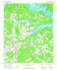
(6)- 1963 Map of Athens
 1963 Athens1963 Print · USGSGeorgia's Piedmont and the Savannah River valley are captured in the early sixties as major reservoirs and military installations reshaped the landscape. Researchers can trace the development of Clark Hill Reservoir, locate the Fort Gordon Military Reservation, and find historic towns like Social Circle and Eatonton.
 - 1964 Map of Lincolnton, 1966 Print
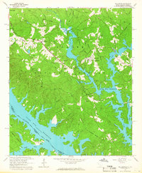
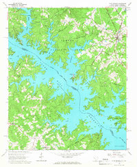
 1964 Lincolnton1966 Print · USGSLincolnton and the Georgia-South Carolina borderlands appear here in the mid-sixties, just as the reservoir system reshaped the Savannah River valley. Genealogists can trace family landmarks and rural congregations like Smith Chapel Cem, Price Grove Ch, and the settlement of Leverett.2 unique versions available
 - 1964 Map of Willington, 1966 Print
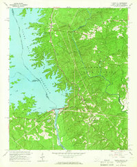
 1964 Willington1966 Print · USGSThe McCormick County borderlands and the Savannah River valley are captured here in the mid-sixties, showcasing the rising waters of the Clark Hill Reservoir. Trace local history at the De La Howe State School and old rural sites like Little Mill Ch Cem.3 unique versions available
 - 1964 Map of Clarks Hill, 1966 Print
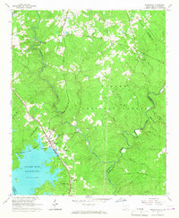
 1964 Clarks Hill1966 Print · USGSThe Savannah River borderlands are captured here in the mid-sixties, just as the newly formed reservoir was reshaping the South Carolina-Georgia line. Genealogists can trace family landmarks like Jones Cem, Bethany Ch, and the Clarks Hill Sch.3 unique versions available
 - 1964 Map of Parksville, 1967 Print
 1964 Parksville1967 Print · USGSThe McCormick County backcountry was undergoing significant change in the 1960s as the Clark Hill Reservoir reshaped the Savannah River valley. Genealogists can trace old community centers like Parksville, Whitetown, and Mims Sch No 2 alongside the Atlantic Coast Line RR.2 unique versions available
 - 1964 Map of Plum Branch, 1967 Print
 1964 Plum Branch1967 Print · USGSThe Savannah River borderlands were being reshaped by the rising reservoir in the mid-sixties, as forests and new shorelines met traditional rail corridors. Genealogists can trace rural communities like Plum Branch, Martins Crossroads, and Republican Ch along the Seaboard Coast Line.2 unique versions available
End of results
Showing maps 1-6 of 6
Top cities of Lincoln County
Frequently asked questions
- What are the different types of historical maps available for Lincoln County?
- What is the oldest map of Lincoln County?
- Where can I purchase historical maps of Lincoln County for my home or office?
- Where can I download high-res historical maps of Lincoln County?
- Are there historical topographic maps available for Lincoln County?
- Is there historical aerial imagery available for Lincoln County?
- Where are historical maps of Lincoln County sourced from?