1970s Maps of Dasher, Georgia
Explore 2 historic maps of Dasher from the 1970s. These maps offer a rare glimpse into what life looked like during the 1970s — showing old roads, neighborhoods, homes, and landmarks that have changed or disappeared over time.
Whether you're researching your family's past, planning a metal detecting trip, or studying how Dasher's landscape evolved across the 1970s, these high-resolution maps are a powerful tool for exploring the history of this region.
- Focus on a specific era: All maps on this page are from the 1970s, giving you a focused view of this time period.
- See what’s changed: Compare century-old streets, trails, and buildings to today's modern landscape using overlays and satellite layers.
- Research with precision: Use these maps for genealogy, historical research, land use analysis, or educational projects.
- View, download, or print: Maps are fully viewable online in high resolution, and can be downloaded or printed for your own records.
Start exploring Dasher's history through authentic maps from the 1970s. This is your window into the past.
Dasher, GA maps
(2)- 1971 Map of Indianola, 1976 Print
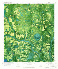 1971 Indianola1976 Print · USGSSouth Georgia's rural landscape is captured here in the early 1970s as two major railroads intersect near the Florida border. Genealogists and local historians can trace the foundations of Indianola and Dasher alongside rural landmarks like Twin Hill Ch and Boring Pond.
 - 1971 Map of Lake Park, 1976 Print
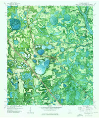 1971 Lake Park1976 Print · USGSSouthern Georgia's lake country is captured in the early 1970s, showcasing the intersection of the railway and the region's unique water-pocked landscape. Genealogists and local historians can trace rural roots at Hickory Grove Cemetery, Frances Lake Ch, and the community of Lake Park.
End of results
Showing maps 1-2 of 2
Top cities near Dasher
Frequently asked questions
- What are the different types of historical maps available for Dasher?
- What is the oldest map of Dasher?
- Where can I purchase historical maps of Dasher for my home or office?
- Where can I download high-res historical maps of Dasher?
- Are there historical topographic maps available for Dasher?
- Is there historical aerial imagery available for Dasher?
- Where are historical maps of Dasher sourced from?