
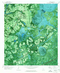
1971 Map of Indianola
USGS Topo · Published 1976About this map
Boring Pond sits as a prominent circular landmark in the center of this South Georgia landscape, where the Lowndes and Echols county line cuts through a mix of agriculture and dense drainage basins. The area is defined by its winding water systems, including Knight Creek and Mud Swamp, which feed into the larger Grand Bay Creek. Transportation infrastructure is a central feature, with the Seaboard Coast Line and Georgia Southern and Florida railroads converging near the Indianola settlement. Local community life is grounded in the rural distribution of sites such as Twin Hill Ch, Mt Pleasant Ch, and Swilley Hill Ch, along with the small cluster of buildings at Dasher. On the western edge, the presence of a Radio Tower (WVLD) and a Lookout Tower marks the transition toward the developing outskirts of the regional hub.
Find a feature on this map
17 named features on this map. Tap any name to fly to it.
Don’t see what you’re looking for? This feature index may not catch every label — zoom into the map to look around manually.
Map Details
Editions of this 1971 Indianola Map
This is the sole edition of this map. No revisions or reprints were ever made.
Other maps of this area

1954 · Valdosta
USGS Topo · 1:250,000

1956 · Clyattville
USGS Topo · 1:24,000

1958 · Valdosta
USGS Topo · 1:250,000

1959 · Valdosta
USGS Topo · 1:250,000

1961 · Hahira East
USGS Topo · 1:24,000

1961 · Valdosta
USGS Topo · 1:24,000

1968 · Naylor
USGS Topo · 1:24,000

1971 · Howell
USGS Topo · 1:24,000

1971 · Lake Park
USGS Topo · 1:24,000
1971 · Bemiss
USGS Topo · 1:24,000