1900s (20th Century) Maps of Marion County, Georgia
Explore 28 historic maps of Marion County from the 1900s (20th Century). These maps offer a rare glimpse into what life looked like during the 1900s — showing old roads, neighborhoods, homes, and landmarks that have changed or disappeared over time.
Whether you're researching your family's past, planning a metal detecting trip, or studying how Marion County's landscape evolved across the 1900s, these high-resolution maps are a powerful tool for exploring the history of this region.
- Focus on a specific era: All maps on this page are from the 1900s, giving you a focused view of this time period.
- See what’s changed: Compare century-old streets, trails, and buildings to today's modern landscape using overlays and satellite layers.
- Research with precision: Use these maps for genealogy, historical research, land use analysis, or educational projects.
- View, download, or print: Maps are fully viewable online in high resolution, and can be downloaded or printed for your own records.
Start exploring Marion County's history through authentic maps from the 1900s. This is your window into the past.
Marion County, GA maps
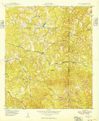
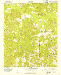
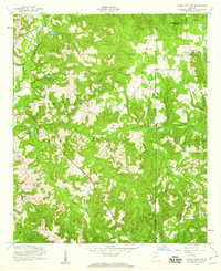
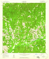
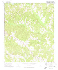
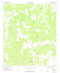
(28)- 1907 Map of Talbotton
 1907 Talbotton1907 Print · USGSWest-central Georgia at the turn of the century is a landscape of ridges and rail-lines, dominated by the thermal waters of Warm Springs. Local historians can trace the foundations of Talbotton and rural life at Turntime Crossroads, Cataula Camp Ground, and Greens Mill.3 unique versions available
 - 1949 Map of Glen Alta
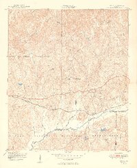
 1949 Glen Alta1949 Print · USGSWestern Georgia at the end of the 1940s reveals a rural landscape increasingly influenced by the expansion of Fort Benning. Researchers can trace the rail paths of the Central Georgia and Seaboard through small communities like Ida Vesper and Glen Alta.2 unique versions available
 - 1949 Map of Upatoi
 1949 Upatoi1949 Print · USGSThe Fort Benning boundary and the Central of Georgia railroad define this corner of Georgia in the late forties. Researchers can trace family landmarks like Mt Carmel Church and the rural settlements at Upatoi and Box Springs.2 unique versions available
 - 1949 Map of Buena Vista NW
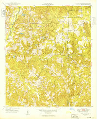 1949 Buena Vista NW1949 Print · USGSChattahoochee and Marion counties appear here in the late 1940s as the expanding military footprint integrated with rural Georgia life. Researchers can trace land use and community hubs like Gallups Mill, John Thomas School, and the remote Fellowship Church.
 - 1950 Map of Geneva, 1953 Print
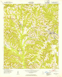
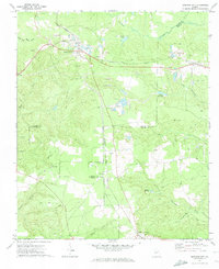
 1950 Geneva1953 Print · USGSMid-century Talbot County is captured here at a time when rural life centered on the railroad and local congregations. Trace the routes through Geneva and Juniper Station to find local landmarks like Oak Grove Ch and Welcome Sch.
 - 1950 Map of Buena Vista NE, 1953 Print
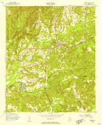
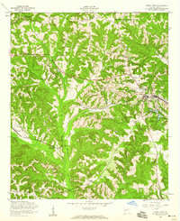
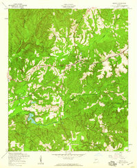
 1950 Buena Vista NE1953 Print · USGSMarion County's rural landscape is captured here at mid-century, defined by small farmsteads and a rich network of community institutions. Local historians can trace the foundations of the area through Parkers Mill, Oakland Sch, and numerous churches like Bethany Ch.
 - 1950 Map of Buena Vista, 1953 Print
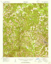
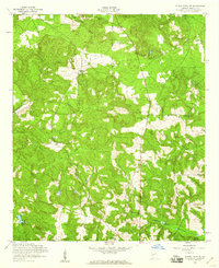
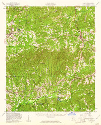
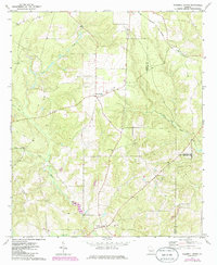
 1950 Buena Vista1953 Print · USGSBuena Vista and the surrounding Marion County countryside are captured here in the early fifties during a period of established rail transit and rural farming. Genealogists can locate family landmarks like St Paul Sch, Ramah Ch, and the Marion County Prison Farm.
 - 1950 Map of Buena Vista, 1955 Print
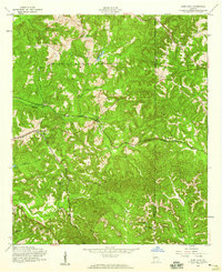
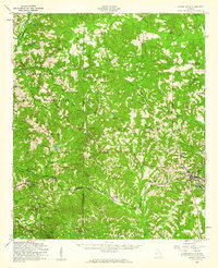
 1950 Buena Vista1955 Print · USGSWest Georgia in the mid-1950s shows a landscape of rural schoolhouses and family-run mills bordering the Fort Benning Military Reservation. Researchers can locate historic rural centers like Brantley, trace the Central of Georgia rail line, and find sites like Callops Mill or Bates Chapel School and Cemetery.
 - 1950 Map of Talbotton, 1955 Print
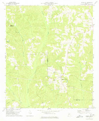
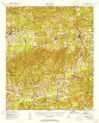 1950 Talbotton1955 Print · USGSWestern Georgia at the start of the fifties reveals a landscape of rural railroad towns and numerous country churches. Genealogists can trace family connections at Waverly Hall Cem or locate old community centers like Box Springs, Geneva, and Matthews Chapel.
 - 1955 Map of Buena Vista NW, 1959 Print
 1955 Buena Vista NW1959 Print · USGSChattahoochee and Marion Counties are shown in the mid-fifties as the military landscape expanded through the Georgia woods. Researchers can locate family landmarks like Gallups Millpond and rural worship sites including County Line Ch.3 unique versions available
 - 1955 Map of Buena Vista, 1959 Print
 1955 Buena Vista1959 Print · USGSMarion County during the mid-fifties reveals a landscape of rural hamlets and small-town commerce centered on Buena Vista. Researchers can trace the Central Georgia railroad to quiet stops like Zellobee or locate family roots at New Providence Ch and Berginville.2 unique versions available
 - 1955 Map of Buena Vista NE, 1959 Print
 1955 Buena Vista NE1959 Print · USGSMarion County was a tapestry of small rural congregations and winding dirt roads during the mid-fifties. Genealogists can trace family connections through sites like Bethlehem Cem, Hickory Tree Ch, and Spring Hill Ch.2 unique versions available
 - 1955 Map of Glen Alta, 1959 Print
 1955 Glen Alta1959 Print · USGSMid-century Chattahoochee County is defined here by the meeting of major rail lines and the expanding grounds of a military outpost. Genealogists and local historians can trace rural landmarks like Zion Hills Ch, the St Mathews Sch, and the junction of the Seaboard Air Line railroad.3 unique versions available
 - 1955 Map of Upatoi, 1959 Print
 1955 Upatoi1959 Print · USGSThe rural borderlands of Talbot and Muscogee counties are captured here in the mid-1950s, split between timbered creeks and federal land. Genealogists can locate family landmarks like Phillips Cem, Mt Paron Ch, and the Crossroads Sch along the Central of Georgia line.3 unique versions available
 - 1955 Map of Geneva, 1959 Print
 1955 Geneva1959 Print · USGSGeneva and the surrounding Georgia countryside are shown in the mid-1950s as the railroad and creek networks dictated local life. Genealogists can trace family roots through Oak Grove Ch, Welcome Ch, and the rural Juniper Sta rail stop.2 unique versions available
 - 1955 Map of Talbotton, 1961 Print
 1955 Talbotton1961 Print · USGSTalbot County and its neighboring parishes are captured here in the mid-fifties, showing the transition between traditional rail-town life and the expanding military presence to the south. Genealogists can trace family roots through numerous rural landmarks like Olive Branch Ch, the Geneva Sch, and Box Springs.2 unique versions available
 - 1955 Map of Buena Vista, 1961 Print
 1955 Buena Vista1961 Print · USGSMid-century Marion County centers on the crossroads of Buena Vista just as the military presence at Fort Benning Military Reservation was expanding. Genealogists and historians can trace family roots through numerous rural landmarks like St Matthew Sch, Liberty Hill Ch, and Glen Alta.
 - 1955 Map of Phenix City, 1964 Print
 1955 Phenix City1964 Print · USGSPost-war Alabama and Georgia meet along the Chattahoochee River as industry and military installations expand. Trace the rail lines of the Central of Georgia through towns like Opelika, Tuskegee, and Alexander City.3 unique versions available
 - 1957 Map of Phenix City
 1957 Phenix City1957 Print · USGSThe Alabama-Georgia borderlands are captured here in the mid-fifties, centered on the bustling river crossing at Phenix City and Columbus. Researchers can trace the mid-century footprint of the Fort Benning Military Reservation or locate smaller textile and railroad towns like Langdale and Camp Hill.
 - 1958 Map of Phenix City
 1958 Phenix City1958 Print · USGSThe Alabama-Georgia borderlands thrive during the late fifties, anchored by the river-driven industry of Columbus and Phenix City. Researchers can trace the mid-century footprints of Fort Benning, Auburn, and the textile towns of Fairfax and Lanett.
 - 1971 Map of Tazewell South, 1974 Print
 1971 Tazewell South1974 Print · USGSMarion and Schley counties in the early 1970s show a landscape of rural hamlets and timberlands tied together by the Central Of Georgia railroad. Genealogists can locate family landmarks like Doyle Cem, Mahala Chapel, and Corinth Cem along the creek-fed hillsides.2 unique versions available
 - 1971 Map of Junction City, 1974 Print
 1971 Junction City1974 Print · USGSRailroads and sand mining define the character of Junction City and the surrounding West Georgia countryside in the early 1970s. Genealogists and local historians can trace family roots at Moores Chapel, Pine Level Cem, and the rural community of Norwich.2 unique versions available
 - 1971 Map of Tazewell North, 1985 Print
 1971 Tazewell North1985 Print · USGSMarion and Taylor counties meet in this rural Georgia landscape during the 1970s and 1980s. Genealogists and local historians can trace family roots at Tazewell, Five Points, and country churches like Mt Olive Ch and Trinity Ch.2 unique versions available
 - 1973 Map of Church Hill, 1974 Print
 1973 Church Hill1974 Print · USGSThe borderlands of Marion and Webster Counties are documented here in the early seventies, showing a landscape defined by traditional rural communities and emerging industry. Researchers can locate specific family landmarks like Old Union Cem, Evans Chapel, and the active Strip Mine near Church Hill.2 unique versions available
 - 1973 Map of Draneville, 1975 Print
 1973 Draneville1975 Print · USGSThe rural crossroads of Marion County are preserved here during the 1970s, showing a landscape of family farms and creek-bottom timber. Genealogists can trace local landmarks like Mt Carmel Ch, the Mt Carmel Cem, and the settlement at Friendship.
Showing maps 1-25 of 28
Top cities of Marion County
Frequently asked questions
- What are the different types of historical maps available for Marion County?
- What is the oldest map of Marion County?
- Where can I purchase historical maps of Marion County for my home or office?
- Where can I download high-res historical maps of Marion County?
- Are there historical topographic maps available for Marion County?
- Is there historical aerial imagery available for Marion County?
- Where are historical maps of Marion County sourced from?