1970s Maps of Tazewell, Georgia
Explore 2 historic maps of Tazewell from the 1970s. These maps offer a rare glimpse into what life looked like during the 1970s — showing old roads, neighborhoods, homes, and landmarks that have changed or disappeared over time.
Whether you're researching your family's past, planning a metal detecting trip, or studying how Tazewell's landscape evolved across the 1970s, these high-resolution maps are a powerful tool for exploring the history of this region.
- Focus on a specific era: All maps on this page are from the 1970s, giving you a focused view of this time period.
- See what’s changed: Compare century-old streets, trails, and buildings to today's modern landscape using overlays and satellite layers.
- Research with precision: Use these maps for genealogy, historical research, land use analysis, or educational projects.
- View, download, or print: Maps are fully viewable online in high resolution, and can be downloaded or printed for your own records.
Start exploring Tazewell's history through authentic maps from the 1970s. This is your window into the past.
Tazewell, GA maps
(2)- 1971 Map of Tazewell South, 1974 Print
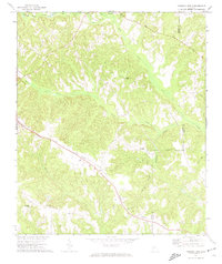 1971 Tazewell South1974 Print · USGSMarion and Schley counties in the early 1970s show a landscape of rural hamlets and timberlands tied together by the Central Of Georgia railroad. Genealogists can locate family landmarks like Doyle Cem, Mahala Chapel, and Corinth Cem along the creek-fed hillsides.2 unique versions available
 - 1971 Map of Tazewell North, 1985 Print
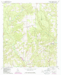 1971 Tazewell North1985 Print · USGSMarion and Taylor counties meet in this rural Georgia landscape during the 1970s and 1980s. Genealogists and local historians can trace family roots at Tazewell, Five Points, and country churches like Mt Olive Ch and Trinity Ch.2 unique versions available
End of results
Showing maps 1-2 of 2
Top cities near Tazewell
- Buena Vista historical maps
- Ellaville historical maps
- Butler historical maps
- Junction City historical maps
- Geneva historical maps
Frequently asked questions
- What are the different types of historical maps available for Tazewell?
- What is the oldest map of Tazewell?
- Where can I purchase historical maps of Tazewell for my home or office?
- Where can I download high-res historical maps of Tazewell?
- Are there historical topographic maps available for Tazewell?
- Is there historical aerial imagery available for Tazewell?
- Where are historical maps of Tazewell sourced from?