1970s Maps of McIntosh County, Georgia
Explore 15 historic maps of McIntosh County from the 1970s. These maps offer a rare glimpse into what life looked like during the 1970s — showing old roads, neighborhoods, homes, and landmarks that have changed or disappeared over time.
Whether you're researching your family's past, planning a metal detecting trip, or studying how McIntosh County's landscape evolved across the 1970s, these high-resolution maps are a powerful tool for exploring the history of this region.
- Focus on a specific era: All maps on this page are from the 1970s, giving you a focused view of this time period.
- See what’s changed: Compare century-old streets, trails, and buildings to today's modern landscape using overlays and satellite layers.
- Research with precision: Use these maps for genealogy, historical research, land use analysis, or educational projects.
- View, download, or print: Maps are fully viewable online in high resolution, and can be downloaded or printed for your own records.
Start exploring McIntosh County's history through authentic maps from the 1970s. This is your window into the past.
McIntosh County, GA maps
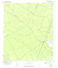
(15)- 1978 Map of Sterling
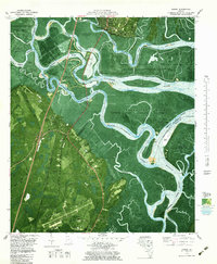
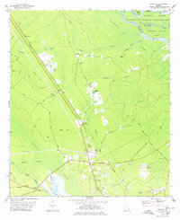 1978 Sterling1978 Print · USGSCoastal Georgia's rail and river landscapes come to life in this late-seventies survey of the wetlands west of Brunswick. Genealogists and historians can trace the paths between the Southern Railway junction at Sterling and local landmarks like Anguilla or Salem Ch.2 unique versions available
 - 1978 Map of East Of Ludowici
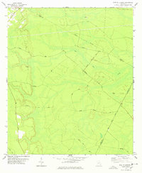 1978 East Of Ludowici1978 Print · USGSCoastal Georgia's backwoods in the late seventies reveal a landscape of timber-linked tracks and hidden family cemeteries. Genealogists and historians can trace the paths between Brickston and Middleton Cem or explore the military footprint of the Bombing Range.
 - 1978 Map of Everett
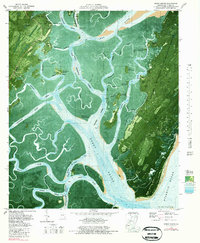
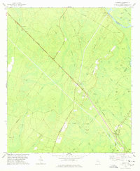 1978 Everett1978 Print · USGSIn the late seventies, the junction at Everett remained a vital rail hub where the Southern and Seaboard Coast Line met near the coastal swamps. Local historians can trace old homesteads and landmarks like Sansavilla Bluff, Mt Pleasant Cem, and the Lookout Tower.
 - 1978 Map of Cox
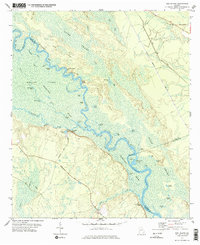
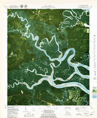
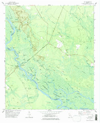 1978 Cox1978 Print · USGSCoastal Georgia's riverine bottomlands are meticulously detailed in the late 1970s, showing the intersection of the Altamaha River and the Seaboard Coast Line. Researchers can locate historic river access points like Ft Barrington Landing and remote family sites such as Sheffield Cem.2 unique versions available
 - 1978 Map of Townsend
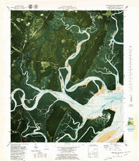
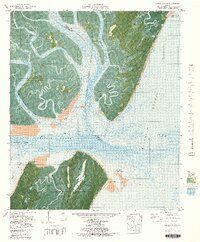
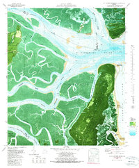
 1978 Townsend1978 Print · USGSThe coastal lowlands of McIntosh County come alive in the late 1970s, showing a landscape defined by timber transport and railroad junctions. Genealogists and historians can trace the tracks of the Seaboard Coast Line and locate early settlements like Townsend and Huxford.
 - 1978 Map of Bug Island
 1978 Bug Island1978 Print · USGSThe Altamaha River bottomlands in the late 1970s reveal a maze of islands and sloughs along the Long and Wayne county lines. Local historians can trace old river access points like Old Landing and Horse Ford or locate the rural Union Ch.2 unique versions available
 - 1978 Map of Brunswick
 1978 Brunswick1978 Print · USGSThe Georgia coast and its barrier islands are captured in the late 1970s, as I-95 and the rail lines shaped the growth of coastal towns. Genealogists and historians can trace family locations across the islands or locate sites near Fort Stewart, Darien, and Ludowici.2 unique versions available
 - 1979 Map of Cabretta Inlet
 1979 Cabretta Inlet1979 Print · USGSGeorgia's barrier islands appear in the late seventies as a protected wilderness where the tide reshapes the shore. Genealogists and historians can trace the locations of Raccoon Bluff, King Savannah, and the coastal site of Salt Boiler.
 - 1979 Map of Altamaha Sound
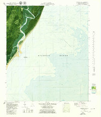
 1979 Altamaha Sound1979 Print · USGSThe Georgia coast in the mid-seventies is captured in this detailed orthophotomap of the Altamaha river delta and barrier islands. Researchers can trace historic boundaries at Cannons Point, navigate the Intracoastal Waterway, and explore the wetlands of Wolf Island.2 unique versions available
 - 1979 Map of Darien
 1979 Darien1979 Print · USGSCoastal Georgia in the late seventies reveals a landscape of tidal rivers and deep-rooted history. Genealogists and historians can trace old landmarks like the Old Slave Cem Evelyn, Old Fort King George, and the Hofwyl-Broadfield Plantation Historic Site.
 - 1979 Map of Doboy Sound
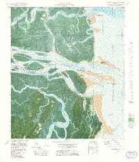
 1979 Doboy Sound1979 Print · USGSThe Georgia coast and Sapelo Island appear in remarkable detail during the late seventies, showing the intricate tidal marshes before modern changes. Genealogists and historians can trace Old Sailors Burying Grounds, the Sapelo Island Sch, and local landmarks like Lumber Landing.2 unique versions available
 - 1979 Map of Seabrook
 1979 Seabrook1979 Print · USGSThe Georgia coast in the late seventies is a labyrinth of tidal rivers and marsh islands where Liberty and McIntosh counties meet. Researchers can trace historical river access and local family landmarks at Halfmoon Landing, Lebanon Cem, and the Tidal Community Sch.2 unique versions available
 - 1979 Map of Shellman Bluff
 1979 Shellman Bluff1979 Print · USGSThe McIntosh County coast in the late 1970s reveals a world of tidal rivers and historic riverside bluffs. Researchers can trace the layout of Contentment Plantation, the roads into Shellman Bluff, and landmarks like Sutherland Bluff.2 unique versions available
 - 1979 Map of Sapelo Sound, 1980 Print
 1979 Sapelo Sound1980 Print · USGSCoastal Georgia in the late seventies is captured here as a labyrinth of barrier islands and tidal channels. Trace the boundaries of the Blackbeard Island National Wildlife Refuge and locate remote landmarks like Cedar Hammock or the shoals of Sapelo Sound.2 unique versions available
 - 1979 Map of St Catherines Sound, 1980 Print
 1979 St Catherines Sound1980 Print · USGSCoastal Georgia's barrier islands and intricate marshes are captured here in the late seventies. Genealogists and local historians can locate Yellow Bluff Fishing Camp, the solitary Cem Grave on St Catherines Island, and the boundaries of Harris Neck National Wildlife Refuge.2 unique versions available
End of results
Showing maps 1-15 of 15
Top cities of McIntosh County
Frequently asked questions
- What are the different types of historical maps available for McIntosh County?
- What is the oldest map of McIntosh County?
- Where can I purchase historical maps of McIntosh County for my home or office?
- Where can I download high-res historical maps of McIntosh County?
- Are there historical topographic maps available for McIntosh County?
- Is there historical aerial imagery available for McIntosh County?
- Where are historical maps of McIntosh County sourced from?