1910s Maps of Murray County, Georgia
Explore 4 historic maps of Murray County from the 1910s. These maps offer a rare glimpse into what life looked like during the 1910s — showing old roads, neighborhoods, homes, and landmarks that have changed or disappeared over time.
Whether you're researching your family's past, planning a metal detecting trip, or studying how Murray County's landscape evolved across the 1910s, these high-resolution maps are a powerful tool for exploring the history of this region.
- Focus on a specific era: All maps on this page are from the 1910s, giving you a focused view of this time period.
- See what’s changed: Compare century-old streets, trails, and buildings to today's modern landscape using overlays and satellite layers.
- Research with precision: Use these maps for genealogy, historical research, land use analysis, or educational projects.
- View, download, or print: Maps are fully viewable online in high resolution, and can be downloaded or printed for your own records.
Start exploring Murray County's history through authentic maps from the 1910s. This is your window into the past.
Murray County, GA maps
(4)- 1911 Map of Cohutta Mtn
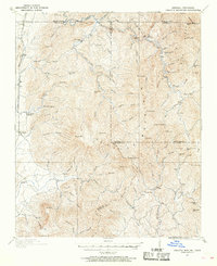 1911 Cohutta Mtn1911 Print · USGSThe Georgia-Tennessee borderlands in the early twentieth century were defined by mountain rail and timber. Genealogists can trace family roots through settlements like Tennga and Crandall or locate historic operations like Hassler Mill along the rail line.2 unique versions available
 - 1913 Map of Cohutta Mtn.
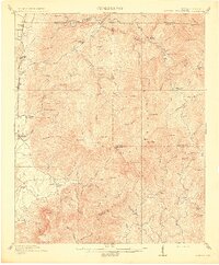 1913 Cohutta Mtn.1913 Print · USGSThe Georgia and Tennessee borderlands appear here in the years before the Great Depression, centered on the high peaks of the Blue Ridge. Researchers can trace early railroad life along the Louisville & Nashville RR or locate old sites like Cohutta Springs and Hassler Mill.3 unique versions available
 - 1914 Map of Talking Rock, 1960 Print
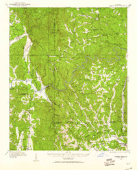 1914 Talking Rock1960 Print · USGSThe foothills of North Georgia are captured here before the mid-century, showing the early communities of Talking Rock and Whitestone along the Louisville and Nashville rail line. Researchers can trace family sites at Ball Creek School, locate river crossings like McClouds Ford, and follow the historic FEDERAL ROAD.2 unique versions available
 - 1916 Map of Talking Rock
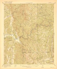 1916 Talking Rock1916 Print · USGSNorth Georgia in the years before the Great War is defined by the winding Coosawattee River and the historic Federal Road. Genealogists can trace family landmarks like Cairns Mill, Clouds Ford, and the old Ball Creek School.2 unique versions available
End of results
Showing maps 1-4 of 4
Top cities of Murray County
Frequently asked questions
- What are the different types of historical maps available for Murray County?
- What is the oldest map of Murray County?
- Where can I purchase historical maps of Murray County for my home or office?
- Where can I download high-res historical maps of Murray County?
- Are there historical topographic maps available for Murray County?
- Is there historical aerial imagery available for Murray County?
- Where are historical maps of Murray County sourced from?