1940s Maps of Dillard, Georgia
Explore 4 historic maps of Dillard from the 1940s. These maps offer a rare glimpse into what life looked like during the 1940s — showing old roads, neighborhoods, homes, and landmarks that have changed or disappeared over time.
Whether you're researching your family's past, planning a metal detecting trip, or studying how Dillard's landscape evolved across the 1940s, these high-resolution maps are a powerful tool for exploring the history of this region.
- Focus on a specific era: All maps on this page are from the 1940s, giving you a focused view of this time period.
- See what’s changed: Compare century-old streets, trails, and buildings to today's modern landscape using overlays and satellite layers.
- Research with precision: Use these maps for genealogy, historical research, land use analysis, or educational projects.
- View, download, or print: Maps are fully viewable online in high resolution, and can be downloaded or printed for your own records.
Start exploring Dillard's history through authentic maps from the 1940s. This is your window into the past.
Dillard, GA maps
(4)- 1946 Map of Dillard, 1956 Print
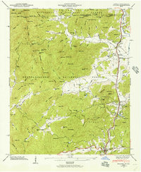 1946 Dillard1956 Print · USGSRabun County mountain life is captured here in the years following the war, centered on the vital passage through Rabun Gap. Local historians can trace the Tallulah Falls RR and locate the Queen Mine, Kilby Mill, and the Rabun Gap Nacoochee Sch.4 unique versions available
 - 1946 Map of Rabun Bald, 1956 Print
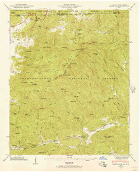 1946 Rabun Bald1956 Print · USGSThe Blue Ridge high country of Georgia and North Carolina is surveyed here just after the war. Local researchers can find family landmarks like Locust School, Hale Church Cem, and the high-elevation flats near Rabun Bald.4 unique versions available
 - 1947 Map of Rabun Bald
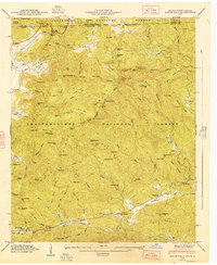 1947 Rabun Bald1947 Print · USGSThe Georgia-North Carolina borderlands appear in the late 1940s as a landscape of isolated mountain communities and forest preserves. Genealogists can locate family landmarks such as Locust School, Hale Church Cem, and the high summit of Rabun Bald.2 unique versions available
 - 1947 Map of Dillard
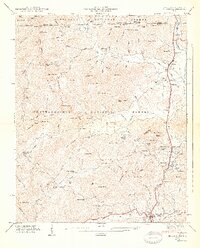 1947 Dillard1947 Print · USGSNorth Georgia and the Carolina border are mapped here just after the war, showing the mountain communities at the headwaters of the Little Tennessee River. Genealogists and historians can locate family landmarks like Wesley Chapel Cem, Dickerson Mill, and the Rabun Gap Nacoochee Sch.2 unique versions available
End of results
Showing maps 1-4 of 4
Top cities near Dillard
- Franklin historical maps
- Clayton historical maps
- Mountain City historical maps
- Tiger historical maps
- Sky Valley historical maps
Frequently asked questions
- What are the different types of historical maps available for Dillard?
- What is the oldest map of Dillard?
- Where can I purchase historical maps of Dillard for my home or office?
- Where can I download high-res historical maps of Dillard?
- Are there historical topographic maps available for Dillard?
- Is there historical aerial imagery available for Dillard?
- Where are historical maps of Dillard sourced from?