1970s Maps of Benevolence, Georgia
Explore 4 historic maps of Benevolence from the 1970s. These maps offer a rare glimpse into what life looked like during the 1970s — showing old roads, neighborhoods, homes, and landmarks that have changed or disappeared over time.
Whether you're researching your family's past, planning a metal detecting trip, or studying how Benevolence's landscape evolved across the 1970s, these high-resolution maps are a powerful tool for exploring the history of this region.
- Focus on a specific era: All maps on this page are from the 1970s, giving you a focused view of this time period.
- See what’s changed: Compare century-old streets, trails, and buildings to today's modern landscape using overlays and satellite layers.
- Research with precision: Use these maps for genealogy, historical research, land use analysis, or educational projects.
- View, download, or print: Maps are fully viewable online in high resolution, and can be downloaded or printed for your own records.
Start exploring Benevolence's history through authentic maps from the 1970s. This is your window into the past.
Benevolence, GA maps
(4)- 1972 Map of Benevolence, 1974 Print
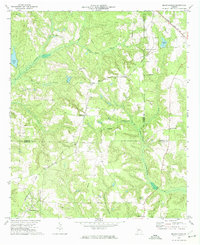 1972 Benevolence1974 Print · USGSSouthwest Georgia in the 1970s shows a landscape of small crossroads and country parishes. Genealogists can trace family footprints near Benevolence or locate rural landmarks like Mt Pleasant Ch and the Seaboard Coast Line.
 - 1972 Map of County Line, 1974 Print
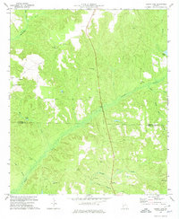 1972 County Line1974 Print · USGSThe Stewart and Randolph county line in the early seventies was a region of quiet settlements and deep creek valleys. Genealogists and historians can trace family locations near Pumpkin Town, Scienceville, and numerous church cemeteries like Piney Grove Ch.
 - 1972 Map of Brooksville, 1974 Print
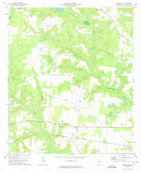 1972 Brooksville1974 Print · USGSRandolph County in the early seventies remained a landscape of quiet rail corridors and scattered rural parishes. Researchers can trace the path of the Central of Georgia railroad through Shellman or locate family landmarks like Pachitla Ch and Lake Marie.
 - 1972 Map of Cuthbert, 1975 Print
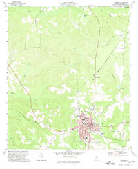 1972 Cuthbert1975 Print · USGSRandolph County's rail-and-college landscape is captured in the early 1970s, centered on the historic streets of Cuthbert. Genealogists can trace family roots at Greenwood Cem and Virgil Chapel, or locate rural settlements like Benevolence and Springvale.
End of results
Showing maps 1-4 of 4
Top cities near Benevolence
- Cuthbert historical maps
- Lumpkin historical maps
- Richland historical maps
- Shellman historical maps
- Preston historical maps
- Coleman historical maps
See more
Frequently asked questions
- What are the different types of historical maps available for Benevolence?
- What is the oldest map of Benevolence?
- Where can I purchase historical maps of Benevolence for my home or office?
- Where can I download high-res historical maps of Benevolence?
- Are there historical topographic maps available for Benevolence?
- Is there historical aerial imagery available for Benevolence?
- Where are historical maps of Benevolence sourced from?