1940s Maps of Bayvale, Augusta
Explore 1 historic maps of Bayvale from the 1940s. These maps offer a rare glimpse into what life looked like during the 1940s — showing old roads, neighborhoods, homes, and landmarks that have changed or disappeared over time.
Whether you're researching your family's past, planning a metal detecting trip, or studying how Bayvale's landscape evolved across the 1940s, these high-resolution maps are a powerful tool for exploring the history of this region.
- Focus on a specific era: All maps on this page are from the 1940s, giving you a focused view of this time period.
- See what’s changed: Compare century-old streets, trails, and buildings to today's modern landscape using overlays and satellite layers.
- Research with precision: Use these maps for genealogy, historical research, land use analysis, or educational projects.
- View, download, or print: Maps are fully viewable online in high resolution, and can be downloaded or printed for your own records.
Start exploring Bayvale's history through authentic maps from the 1940s. This is your window into the past.
Bayvale, Augusta maps
(1)- 1948 Map of Hephzibah
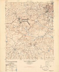 1948 Hephzibah1948 Print · USGSRichmond County and the Augusta suburbs are seen here during the late 1940s as military footprints like Camp Gordon began to reshape the landscape. Genealogists and local historians can locate dozens of country churches and rural cemeteries, from the Albion-Kaolin Chalk Mine to the Georgia Training School Farm.2 unique versions available
End of results
Showing maps 1-1 of 1
Top cities near Bayvale
- Augusta historical maps
- North Augusta historical maps
- Grovetown historical maps
- Hephzibah historical maps
- Burnettown historical maps
Frequently asked questions
- What are the different types of historical maps available for Bayvale?
- What is the oldest map of Bayvale?
- Where can I purchase historical maps of Bayvale for my home or office?
- Where can I download high-res historical maps of Bayvale?
- Are there historical topographic maps available for Bayvale?
- Is there historical aerial imagery available for Bayvale?
- Where are historical maps of Bayvale sourced from?