1900s (20th Century) Maps of Toccoa, Georgia
Explore 7 historic maps of Toccoa from the 1900s (20th Century). These maps offer a rare glimpse into what life looked like during the 1900s — showing old roads, neighborhoods, homes, and landmarks that have changed or disappeared over time.
Whether you're researching your family's past, planning a metal detecting trip, or studying how Toccoa's landscape evolved across the 1900s, these high-resolution maps are a powerful tool for exploring the history of this region.
- Focus on a specific era: All maps on this page are from the 1900s, giving you a focused view of this time period.
- See what’s changed: Compare century-old streets, trails, and buildings to today's modern landscape using overlays and satellite layers.
- Research with precision: Use these maps for genealogy, historical research, land use analysis, or educational projects.
- View, download, or print: Maps are fully viewable online in high resolution, and can be downloaded or printed for your own records.
Start exploring Toccoa's history through authentic maps from the 1900s. This is your window into the past.
Toccoa, GA maps
(7)- 1954 Map of Greenville, 1965 Print
 1954 Greenville1965 Print · USGSThe Upstate and Northeast Georgia are captured here during a decade of massive transformation as new reservoirs reshaped the Piedmont. Genealogists and hikers can trace the Appalachian Trail over Brasstown Bald or locate old community centers like Demorest, Westminster, and Royston.3 unique versions available
 - 1957 Map of Tugaloo Lake, 1958 Print
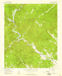 1957 Tugaloo Lake1958 Print · USGSThe river borders of Georgia and South Carolina come alive in the 1950s as they wind through the deep mountain forests of Rabun and Oconee counties. Researchers can trace the hydroelectric developments at Tugaloo Lake or locate family landmarks like Prather Bridge and Old Liberty Ch.4 unique versions available
 - 1958 Map of Greenville
 1958 Greenville1958 Print · USGSThe Piedmont and Blue Ridge foothills come alive in this mid-century survey of the Upstate and Northeast Georgia. Trace the regional rail-and-river economy through the Southern Railway corridors and early reservoir developments like Lake Sidney Lanier.
 - 1964 Map of Ayersville, 1965 Print
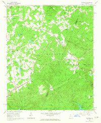 1964 Ayersville1965 Print · USGSNortheast Georgia in the mid-sixties reveals a landscape of national forest land, mountain ridges, and rail-side settlements. Genealogists and historians can trace family-named sites like Shorts Mill, Ducket Lake, and churches such as Mt Bethel Ch or Antioch Ch.3 unique versions available
 - 1964 Map of Toccoa, 1966 Print
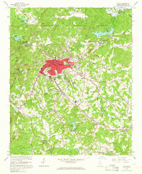 1964 Toccoa1966 Print · USGSIn the foothills of Northeast Georgia, this mid-century survey captures the city of Toccoa at a time of steady growth and industrial expansion. Genealogists and local historians can trace family roots through landmarks like the Toccoa Falls Institute, the Philadelphia Cem & Ch, and the rural community of Eastanollee.2 unique versions available
 - 1981 Map of Toccoa, 1982 Print
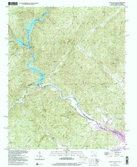
 1981 Toccoa1982 Print · USGSThe tri-state mountain region where Georgia meets the Carolinas is shown here in the early eighties. Genealogists and historians can trace family-named locations and settlements from Dahlonega to Tallulah Falls, along with the Southern rail corridor.2 unique versions available
 - 1997 Map of Tugaloo Lake, 2001 Print
 1997 Tugaloo Lake2001 Print · USGSThe Georgia and South Carolina borderlands are defined by the winding Tugaloo River and its reservoirs in the late nineties. Genealogists can trace rural life through landmarks like Old Liberty Church, Bethlehem School, and the Prather Bridge crossing.
End of results
Showing maps 1-7 of 7
Top cities near Toccoa
- Cornelia historical maps
- Baldwin historical maps
- Westminster historical maps
- Lavonia historical maps
- Clarkesville historical maps
- Demorest historical maps
See more
Top neighborhoods of Toccoa
Frequently asked questions
- What are the different types of historical maps available for Toccoa?
- What is the oldest map of Toccoa?
- Where can I purchase historical maps of Toccoa for my home or office?
- Where can I download high-res historical maps of Toccoa?
- Are there historical topographic maps available for Toccoa?
- Is there historical aerial imagery available for Toccoa?
- Where are historical maps of Toccoa sourced from?