1970s Maps of Sumter County, Georgia
Explore 17 historic maps of Sumter County from the 1970s. These maps offer a rare glimpse into what life looked like during the 1970s — showing old roads, neighborhoods, homes, and landmarks that have changed or disappeared over time.
Whether you're researching your family's past, planning a metal detecting trip, or studying how Sumter County's landscape evolved across the 1970s, these high-resolution maps are a powerful tool for exploring the history of this region.
- Focus on a specific era: All maps on this page are from the 1970s, giving you a focused view of this time period.
- See what’s changed: Compare century-old streets, trails, and buildings to today's modern landscape using overlays and satellite layers.
- Research with precision: Use these maps for genealogy, historical research, land use analysis, or educational projects.
- View, download, or print: Maps are fully viewable online in high resolution, and can be downloaded or printed for your own records.
Start exploring Sumter County's history through authentic maps from the 1970s. This is your window into the past.
Sumter County, GA maps
(17)- 1972 Map of Drayton, 1974 Print
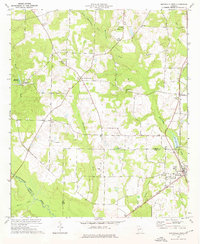
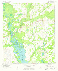 1972 Drayton1974 Print · USGSDooly County during the early seventies is mapped here as the Flint River expands into the backwaters of northern Lake Blackshear. Genealogists and local historians can locate rural landmarks like Macedonia Ch, Collier Cem, and the river crossing at Luther Storey Bridge.2 unique versions available
 - 1972 Map of Ellaville South, 1975 Print
 1972 Ellaville South1975 Print · USGSSchley County in the early seventies centers on the rail-and-creek economy of the Georgia coastal plain. Genealogists and local historians can trace rural congregations and family burial sites including Union Hill Ch, Ebenezer Cem, and Jerusalem Ch.
 - 1972 Map of Methvins, 1975 Print
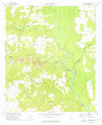
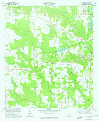
 1972 Methvins1975 Print · USGSSumter County farmland and creek bottoms appear in detail in the early 1970s. Researchers can locate community anchors like Union Grove Ch and Bethel Ch, or trace the winding course of the Flint River near Methvins.2 unique versions available
 - 1972 Map of Andersonville, 1975 Print
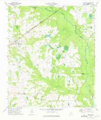
 1972 Andersonville1975 Print · USGSAndersonville and the surrounding Georgia countryside are documented here in the early seventies, showing the landscape before modern development. Researchers can locate the Andersonville National Historic Site, Mt Olive Cem, and the tracks of the Central of Georgia railroad.
 - 1972 Map of Pennington, 1975 Print
 1972 Pennington1975 Print · USGSMacon and Sumter counties meet along the winding Flint River in the early 1970s, as industrial mining reshapes the rural landscape. Genealogists and historians can trace family sites like Tolen Cem or explore the grounds of Chamblis Mill and the Indian Mounds.
 - 1973 Map of Americus, 1975 Print
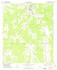
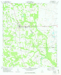
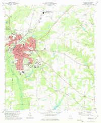 1973 Americus1975 Print · USGSAmericus was a thriving South Georgia center in the mid-1970s, defined by its historic college campus and a busy junction of multiple rail lines. Genealogists and historians can trace family roots through numerous sites like Mt Moriah Ch, Gatewood Cem, and Souther Field.2 unique versions available
 - 1973 Map of Plains, 1975 Print
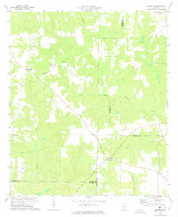
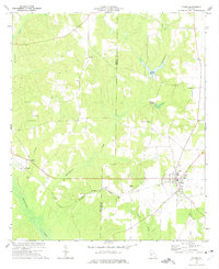 1973 Plains1975 Print · USGSThe rural agricultural landscape of Sumter County is captured here in the early seventies, centered on the community of Plains. Genealogists and historians can trace rail-side hamlets like Archery, old burial grounds like Lebanon Cem, and several local landmarks including Youngs Millpond.2 unique versions available
 - 1973 Map of Bottsford, 1975 Print
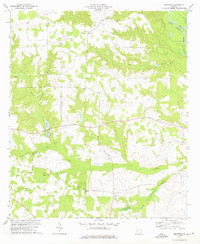
 1973 Bottsford1975 Print · USGSWest Georgia's rural landscape at the start of the 1970s is captured here as the borders of three counties meet. Researchers can trace family sites and local history through numerous landmarks like Bottsford, Providence Cem, and Wallers Ch.
 - 1973 Map of Lake Collins, 1975 Print
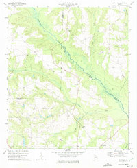
 1973 Lake Collins1975 Print · USGSSumter County was a landscape of rail-linked hamlets and creekside farms in the early seventies. Genealogists and historians can trace the foundations of local life through the Antioch Ch Cem, Ebenezer Ch, and the crossroads at New Point.2 unique versions available
 - 1973 Map of Draneville, 1975 Print
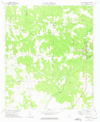
 1973 Draneville1975 Print · USGSThe rural crossroads of Marion County are preserved here during the 1970s, showing a landscape of family farms and creek-bottom timber. Genealogists can trace local landmarks like Mt Carmel Ch, the Mt Carmel Cem, and the settlement at Friendship.
 - 1973 Map of Bronwood, 1975 Print
 1973 Bronwood1975 Print · USGSBronwood and the Terrell County countryside are shown here in the early seventies, a landscape of family farms and rural churches. Genealogists can trace local landmarks like Bridges Crossroad, Greater Macedonia Ch, and the Old Church Cem.
 - 1973 Map of Leslie, 1975 Print
 1973 Leslie1975 Print · USGSSumter and Lee Counties come into focus in the early 1970s, showcasing a community built on agriculture and rail transport. Genealogists can trace family roots through numerous local landmarks like Union High School, Jackson Grove Church, and Mt Zion Cemetery.
 - 1973 Map of Smithville West, 1976 Print
 1973 Smithville West1976 Print · USGSThe agricultural plains of Sumter and Lee Counties are captured here in the early seventies, centered on the rail-side community of Smithville. Researchers can find numerous rural landmarks, from the Smithville Academy and Green Grove Sch to historic congregations at Hebron Ch and St Pauls Ch.
 - 1973 Map of Smithville East, 1976 Print
 1973 Smithville East1976 Print · USGSSumter and Lee Counties in the early seventies reveal a landscape of deep creek bottoms and railroad corridors. Genealogists and historians can trace family roots through the Anthony Cem, Deldrich Cem, and Mt Pleasant Ch.2 unique versions available
 - 1977 Map of Cobb
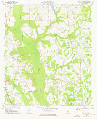
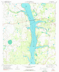 1977 Cobb1977 Print · USGSLake Blackshear and the Flint River shoreline define this South Georgia landscape during the 1970s. Researchers can trace rural church history at New Zion Ch and Springhill Ch or locate the old Seaboard Coast Line rail corridor.2 unique versions available
 - 1977 Map of Hawkinsville
 1977 Hawkinsville1977 Print · USGSSouth Georgia’s agricultural and rail heartland is meticulously documented during the late seventies. Researchers can trace family ties and transit routes through old depots and towns like Unadilla, Pineview, and Hawkinsville along the Ocmulgee River.
 - 1978 Map of Hawkinsville, 1979 Print
 1978 Hawkinsville1979 Print · USGSMiddle Georgia's agricultural and rail heartland is captured here in the late seventies, showing the vital connections between the Ocmulgee River and the rural plains. Genealogists and historians can trace family locations near Vienna, Hawkinsville, or along the tracks of the Southern railroad.
End of results
Showing maps 1-17 of 17
Top cities of Sumter County
Frequently asked questions
- What are the different types of historical maps available for Sumter County?
- What is the oldest map of Sumter County?
- Where can I purchase historical maps of Sumter County for my home or office?
- Where can I download high-res historical maps of Sumter County?
- Are there historical topographic maps available for Sumter County?
- Is there historical aerial imagery available for Sumter County?
- Where are historical maps of Sumter County sourced from?