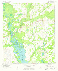
1972 Map of Drayton
USGS Topo · Published 1974About this map
The Flint River corridor defines the western edge of this early 1970s survey, where the river widens significantly into the northern reaches of Lake Blackshear. The landscape is a complex network of wetlands and backwaters, featuring evocative local names such as Whisky Island, Glory Hole, and Parkers Slough. Near the center of the sheet, the settlement of Drayton serves as a small focal point, connected to the western bank by the Luther Storey Bridge. Away from the river, the terrain transitions into agricultural land and timber tracts drained by numerous waterways like Turkey Creek and Pennahatchee Creek. For local historians and genealogists, the map preserves the locations of rural community centers, including Macedonia Ch, Shady Grove Ch, and the Collier Cem. The presence of a Landing Strip and various boat landings highlights the area's reliance on both recreational and light transport infrastructure during this period.
Find a feature on this map
34 named features on this map. Tap any name to fly to it.
Don’t see what you’re looking for? This feature index may not catch every label — zoom into the map to look around manually.
Map Details
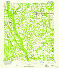
Editions of this 1972 Drayton Map
2 editions found

Other maps of this area

1953 · Dothan
USGS Topo · 1:250,000

1953 · Waycross
USGS Topo · 1:250,000

1954 · Dothan
USGS Topo · 1:250,000

1955 · Dothan
USGS Topo · 1:250,000

1955 · Phenix City
USGS Topo · 1:250,000
1956 · Leslie
USGS Topo · 1:62,500

1957 · Phenix City
USGS Topo · 1:250,000

1957 · Macon
USGS Topo · 1:250,000

1958 · Macon
USGS Topo · 1:250,000

1958 · Phenix City
USGS Topo · 1:250,000