Old Maps of Troup County, Georgia for Hiking & Exploration
Hike through history with 111 historic maps of Troup County. Explore old trails, ghost towns, and forgotten backroads — perfect for outdoor adventurers and local explorers.
- Rediscover forgotten places: Map out old mining camps, roads, and footpaths that no longer exist on modern maps.
- Layer with modern tools: Combine with LiDAR or satellite views to plan hikes through historical terrain.
- Made for exploration: Popular among hikers, overlanders, and local history lovers.
Use these maps to find adventure and explore the hidden past of Troup County.
Troup County, GA maps
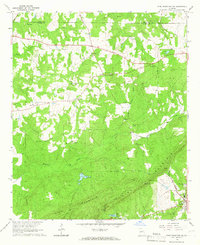
(111)- 1899 Map of Wedowee, 1958 Print
 1899 Wedowee1958 Print · USGSEastern Alabama and western Georgia are mapped here at the close of the nineteenth century, documenting the rural river-and-rail landscape. Researchers can trace historic crossings like Philpots Ferry and early industrial sites such as the Copper Mine.
 - 1902 Map of Wedowee
 1902 Wedowee1902 Print · USGSThe Alabama and Georgia state line bisects this turn-of-the-century landscape of river crossings and hill-country settlements. Genealogists can trace early homesteads and commerce at Philpots Ferry, the Copper Mine, or the town of Wedowee.3 unique versions available
 - 1907 Map of Talbotton
 1907 Talbotton1907 Print · USGSWest-central Georgia at the turn of the century is a landscape of ridges and rail-lines, dominated by the thermal waters of Warm Springs. Local historians can trace the foundations of Talbotton and rural life at Turntime Crossroads, Cataula Camp Ground, and Greens Mill.3 unique versions available
 - 1907 Map of Opelika, 1963 Print
 1907 Opelika1963 Print · USGSEastern Alabama and western Georgia come alive in this early 1900s survey of the rail-and-river economy. Genealogists can trace family names at Mitchell Crossroads, find rural landmarks like the Poor Farm, and locate historic river crossings like Dixon Ferry.
 - 1909 Map of Opelika
 1909 Opelika1909 Print · USGSEastern Alabama and western Georgia are seen here in the first decade of the twentieth century as the river-and-rail economy reached its peak. Genealogists and historians can trace old river crossings like Blanton Ferry, rural post offices such as Antioch Church Huckabee P O, and the path of the Chattahoochee Valley railroad.4 unique versions available
 - 1953 Map of Atlanta, 1965 Print
 1953 Atlanta1965 Print · USGSThe growing Atlanta metro and the industrial corridors of Eastern Alabama are captured here during the mid-century transition. Researchers can trace the rail-to-road shift through hubs like Anniston and La Grange or locate sites within Fort McClellan.2 unique versions available
 - 1955 Map of Phenix City, 1964 Print
 1955 Phenix City1964 Print · USGSPost-war Alabama and Georgia meet along the Chattahoochee River as industry and military installations expand. Trace the rail lines of the Central of Georgia through towns like Opelika, Tuskegee, and Alexander City.3 unique versions available
 - 1957 Map of Phenix City
 1957 Phenix City1957 Print · USGSThe Alabama-Georgia borderlands are captured here in the mid-fifties, centered on the bustling river crossing at Phenix City and Columbus. Researchers can trace the mid-century footprint of the Fort Benning Military Reservation or locate smaller textile and railroad towns like Langdale and Camp Hill.
 - 1957 Map of Atlanta
 1957 Atlanta1957 Print · USGSAtlanta and the Alabama borderlands appear here in the mid-fifties, capturing the region's post-war suburban and industrial transition. Trace the development of early transport hubs and military sites like Fort McPherson, Anniston, and the Kennesaw Mountain National Battlefield Park.
 - 1958 Map of Phenix City
 1958 Phenix City1958 Print · USGSThe Alabama-Georgia borderlands thrive during the late fifties, anchored by the river-driven industry of Columbus and Phenix City. Researchers can trace the mid-century footprints of Fort Benning, Auburn, and the textile towns of Fairfax and Lanett.
 - 1958 Map of Atlanta
 1958 Atlanta1958 Print · USGSMid-century Georgia and Alabama are shown in this regional study of the corridor between the Chattahoochee River and the Appalachian foothills. Local historians can trace the development of suburban Atlanta alongside vital landmarks like Stone Mountain, Dobbins AFB, and the Seaboard Air Line rail routes.
 - 1964 Map of Whitesville, 1965 Print
 1964 Whitesville1965 Print · USGSThe Georgia-Alabama border along the Chattahoochee River comes to life in the mid-1960s. Researchers can trace rural lineages through family landmarks like Billingslea Cem, Jones Crossroads, and Flat Shoal Ch.3 unique versions available
 - 1964 Map of Cannonville, 1965 Print
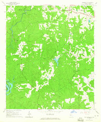
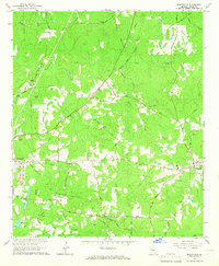
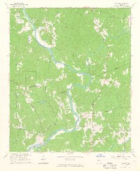
 1964 Cannonville1965 Print · USGSTroup County's rural crossroads and ridge-top settlements are captured here in the mid-sixties. Local researchers can trace family lands near Gray Hill Ch, locate ancestral burials at Hammetts Cem, and follow the old routes through Cannonville.4 unique versions available
 - 1964 Map of Hogansville, 1965 Print
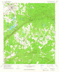
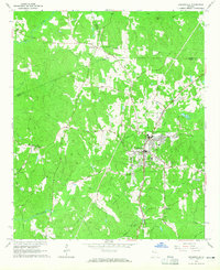 1964 Hogansville1965 Print · USGSHogansville and its surrounding crossroads are captured here in the mid-1960s, showing a landscape defined by the Atlanta and West Point rail line. Genealogists can trace family landmarks like Myrtle Hill Cemetery and old rural meeting places such as Harmonia Ch or Corinth.3 unique versions available
 - 1964 Map of Lanett North, 1965 Print
 1964 Lanett North1965 Print · USGSThe industrial and civic heart of the Alabama-Georgia border comes into focus in this mid-sixties survey. Local historians can trace the development of Lanett and West Point through sites like Fort Tyler Cem, Harrison High Sch, and the Atlanta and West Point Railroad.4 unique versions available
 - 1964 Map of Mountville, 1965 Print
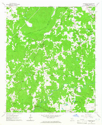
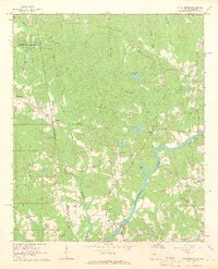
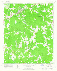
 1964 Mountville1965 Print · USGSTroup County in the mid-sixties remains a landscape of traditional family-named roads and rural rail crossings. Genealogists and local historians can trace family sites at the Traylor-Johnson Cem, Mount Pleasant Sch, and the community of Mountville.3 unique versions available
 - 1964 Map of Abbottsford, 1966 Print
 1964 Abbottsford1966 Print · USGSThe Alabama-Georgia state line in the mid-1960s was a landscape of river-valley communities and rural rail stops. You can trace family-named roads and historic crossings like the Covered Bridge, Glass Bridge, and the Atlantic Coast Line railroad.5 unique versions available
 - 1964 Map of La Grange, 1966 Print
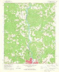
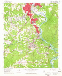
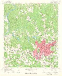 1964 La Grange1966 Print · USGSLa Grange and Troup County appear in the mid-sixties as a thriving textile and education center just east of the Chattahoochee. Researchers can trace the town's expansion through sites like La Grange College, Stonewall Cem, and the Dunson Mills Sch.3 unique versions available
 - 1964 Map of Glenn, 1966 Print
 1964 Glenn1966 Print · USGSThe Georgia-Alabama borderlands come alive in the mid-1960s, showing a rural landscape of crossroads settlements and small country parishes. Family historians can trace ancestral sites like Pleasant Grove Ch, Liberty Hill Cem, and the old community at Denver.2 unique versions available
 - 1964 Map of Lanett South, 1966 Print
 1964 Lanett South1966 Print · USGSThe industrial corridor of the Chattahoochee Valley comes alive here in the mid-1960s, showing the tight-knit mill towns and rail networks of eastern Alabama. Researchers can trace the legacy of local families through Oak Wood Cem, Huguley Cem, and numerous country churches like Greenwood Ch.4 unique versions available
 - 1964 Map of Hillcrest, 1966 Print
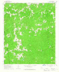
 1964 Hillcrest1966 Print · USGSHeard and Troup counties come alive in the mid-sixties, showing a landscape of river-bend settlements and old rural crossings. Researchers can trace family history through sites like the Sanitarium at Hillcrest, the Old Philpot Ferry, and country churches like Shiloh Ch.3 unique versions available
 - 1964 Map of Pine Mountain, 1966 Print
 1964 Pine Mountain1966 Print · USGSHarris County and the ridges of the Pine Mountain range were transitioning into a major recreational corridor in the mid-sixties. Genealogists and local historians can trace the foundations of Pine Mountain Valley, locate the Whitehead Cemetery, and explore the early layout of Callaway Gardens.
 - 1964 Map of Grantville, 1966 Print
 1964 Grantville1966 Print · USGSWest-central Georgia at the height of the sixties is documented here as the railroad corridor connects rural communities across three counties. Genealogists can trace family names at Holly Springs Cem or locate the High Sch and St Pauls Ch in the Lone Oak area.3 unique versions available
 - 1964 Map of Pine Mountain SW, 1966 Print
 1964 Pine Mountain SW1966 Print · USGSHarris County in the mid-sixties reveals a landscape of ridge-top lookouts and deep-seated rural traditions as the timber and rail economy thrived. Researchers can trace family sites at Old Hopewell Cem, visit Smiths Crossroads, or locate the historic Carver High Sch.2 unique versions available
 - 1964 Map of Durand, 1966 Print
 1964 Durand1966 Print · USGSWestern Georgia at the start of the sixties reveals a transition from rail-dependent commerce to a rural landscape of family homesteads. Genealogists can locate family burial sites at Ogletree Cem and Hardy Cem or trace the Atlantic Coast Line through Durand.
Showing maps 1-25 of 111
Top cities of Troup County
Frequently asked questions
- What are the different types of historical maps available for Troup County?
- What is the oldest map of Troup County?
- Where can I purchase historical maps of Troup County for my home or office?
- Where can I download high-res historical maps of Troup County?
- Are there historical topographic maps available for Troup County?
- Is there historical aerial imagery available for Troup County?
- Where are historical maps of Troup County sourced from?