1960s Maps of LaGrange, Georgia
Explore 4 historic maps of LaGrange from the 1960s. These maps offer a rare glimpse into what life looked like during the 1960s — showing old roads, neighborhoods, homes, and landmarks that have changed or disappeared over time.
Whether you're researching your family's past, planning a metal detecting trip, or studying how LaGrange's landscape evolved across the 1960s, these high-resolution maps are a powerful tool for exploring the history of this region.
- Focus on a specific era: All maps on this page are from the 1960s, giving you a focused view of this time period.
- See what’s changed: Compare century-old streets, trails, and buildings to today's modern landscape using overlays and satellite layers.
- Research with precision: Use these maps for genealogy, historical research, land use analysis, or educational projects.
- View, download, or print: Maps are fully viewable online in high resolution, and can be downloaded or printed for your own records.
Start exploring LaGrange's history through authentic maps from the 1960s. This is your window into the past.
LaGrange, GA maps
(4)- 1964 Map of Cannonville, 1965 Print
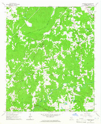 1964 Cannonville1965 Print · USGSTroup County's rural crossroads and ridge-top settlements are captured here in the mid-sixties. Local researchers can trace family lands near Gray Hill Ch, locate ancestral burials at Hammetts Cem, and follow the old routes through Cannonville.4 unique versions available
 - 1964 Map of Mountville, 1965 Print
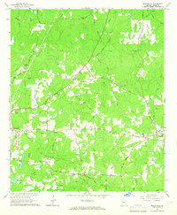 1964 Mountville1965 Print · USGSTroup County in the mid-sixties remains a landscape of traditional family-named roads and rural rail crossings. Genealogists and local historians can trace family sites at the Traylor-Johnson Cem, Mount Pleasant Sch, and the community of Mountville.3 unique versions available
 - 1964 Map of La Grange, 1966 Print
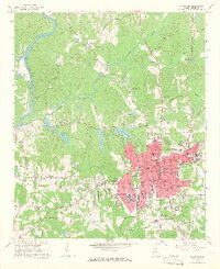 1964 La Grange1966 Print · USGSLa Grange and Troup County appear in the mid-sixties as a thriving textile and education center just east of the Chattahoochee. Researchers can trace the town's expansion through sites like La Grange College, Stonewall Cem, and the Dunson Mills Sch.3 unique versions available
 - 1964 Map of Hilyer, 1966 Print
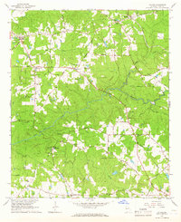 1964 Hilyer1966 Print · USGSTroup County’s rural landscape is captured here in the mid-1960s, a time when small agricultural communities like Hilyer and Big Springs thrived. Local researchers can trace family roots at Smiths Mill or explore the many named burial grounds like Talley Cem and McGee Cem.2 unique versions available
End of results
Showing maps 1-4 of 4
Top cities near LaGrange
- Valley historical maps
- Lanett historical maps
- West Point historical maps
- Grantville historical maps
- Hogansville historical maps
- Huguley historical maps
See more
Top neighborhoods of LaGrange
- Sassafrass Hills historical maps
- Eagles Rest historical maps
- Foxcroft historical maps
- Holly Hill historical maps
- Willowcrest historical maps
- Ashling Place historical maps
See more
Frequently asked questions
- What are the different types of historical maps available for LaGrange?
- What is the oldest map of LaGrange?
- Where can I purchase historical maps of LaGrange for my home or office?
- Where can I download high-res historical maps of LaGrange?
- Are there historical topographic maps available for LaGrange?
- Is there historical aerial imagery available for LaGrange?
- Where are historical maps of LaGrange sourced from?