1930s Maps of Blairsville, Georgia
Explore 3 historic maps of Blairsville from the 1930s. These maps offer a rare glimpse into what life looked like during the 1930s — showing old roads, neighborhoods, homes, and landmarks that have changed or disappeared over time.
Whether you're researching your family's past, planning a metal detecting trip, or studying how Blairsville's landscape evolved across the 1930s, these high-resolution maps are a powerful tool for exploring the history of this region.
- Focus on a specific era: All maps on this page are from the 1930s, giving you a focused view of this time period.
- See what’s changed: Compare century-old streets, trails, and buildings to today's modern landscape using overlays and satellite layers.
- Research with precision: Use these maps for genealogy, historical research, land use analysis, or educational projects.
- View, download, or print: Maps are fully viewable online in high resolution, and can be downloaded or printed for your own records.
Start exploring Blairsville's history through authentic maps from the 1930s. This is your window into the past.
Blairsville, GA maps
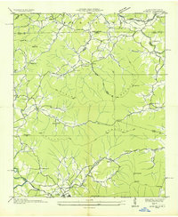
(3)- 1935 Map of Coosa Bald
 1935 Coosa Bald1935 Print · USGSUnion County, Georgia, is captured during the mid-thirties as the river valleys were being surveyed for infrastructure and conservation. Genealogists and historians can trace family locations near Cowden Cem, Choestoe, and rural landmarks like Trackrock School.
 - 1935 Map of Gumlog
 1935 Gumlog1935 Print · USGSUpper Georgia and North Carolina meet in this mid-1930s landscape, where mountain gaps and creek valleys dictate the layout of rural life. Researchers can trace the heritage of remote settlements like Gumlog and find local landmarks such as Ownby Mill and Zebulon Ch.
 - 1938 Map of Coosa Bald
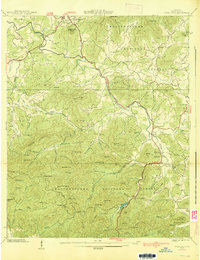 1938 Coosa Bald1938 Print · USGSUnion County and the mountain seat of Blairsville are captured here in the late 1930s, showing a landscape of high ridges and deep river valleys. Genealogists can locate family-named landmarks like Butt Cem and early community centers such as Shadydale Sch and Coosa Ch.3 unique versions available
End of results
Showing maps 1-3 of 3
Top cities near Blairsville
- Murphy historical maps
- Hiawassee historical maps
- Helen historical maps
- Young Harris historical maps
- Hayesville historical maps
Frequently asked questions
- What are the different types of historical maps available for Blairsville?
- What is the oldest map of Blairsville?
- Where can I purchase historical maps of Blairsville for my home or office?
- Where can I download high-res historical maps of Blairsville?
- Are there historical topographic maps available for Blairsville?
- Is there historical aerial imagery available for Blairsville?
- Where are historical maps of Blairsville sourced from?