1980s Maps of Blairsville, Georgia
Explore 3 historic maps of Blairsville from the 1980s. These maps offer a rare glimpse into what life looked like during the 1980s — showing old roads, neighborhoods, homes, and landmarks that have changed or disappeared over time.
Whether you're researching your family's past, planning a metal detecting trip, or studying how Blairsville's landscape evolved across the 1980s, these high-resolution maps are a powerful tool for exploring the history of this region.
- Focus on a specific era: All maps on this page are from the 1980s, giving you a focused view of this time period.
- See what’s changed: Compare century-old streets, trails, and buildings to today's modern landscape using overlays and satellite layers.
- Research with precision: Use these maps for genealogy, historical research, land use analysis, or educational projects.
- View, download, or print: Maps are fully viewable online in high resolution, and can be downloaded or printed for your own records.
Start exploring Blairsville's history through authentic maps from the 1980s. This is your window into the past.
Blairsville, GA maps
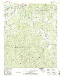
(3)- 1981 Map of Toccoa, 1982 Print
 1981 Toccoa1982 Print · USGSThe tri-state mountain region where Georgia meets the Carolinas is shown here in the early eighties. Genealogists and historians can trace family-named locations and settlements from Dahlonega to Tallulah Falls, along with the Southern rail corridor.2 unique versions available
 - 1988 Map of Coosa Bald
 1988 Coosa Bald1988 Print · USGSIn the late 1980s, the mountain community of Blairsville was a center of mountain commerce and mountain-valley farming. Genealogists can locate family landmarks such as Henson Cem, Mathis Cem, and Shady Grove Ch among the high ridges.2 unique versions available
 - 1988 Map of Blairsville
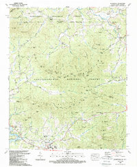 1988 Blairsville1988 Print · USGSNorth Georgia and the North Carolina border meet in the late eighties at the foot of the Blue Ridge Mountains. Genealogists and historians can trace community roots through numerous landmarks like Pine Log Village, Henderson Cem, and Many Forks Ch.
End of results
Showing maps 1-3 of 3
Top cities near Blairsville
- Murphy historical maps
- Hiawassee historical maps
- Helen historical maps
- Young Harris historical maps
- Hayesville historical maps
Frequently asked questions
- What are the different types of historical maps available for Blairsville?
- What is the oldest map of Blairsville?
- Where can I purchase historical maps of Blairsville for my home or office?
- Where can I download high-res historical maps of Blairsville?
- Are there historical topographic maps available for Blairsville?
- Is there historical aerial imagery available for Blairsville?
- Where are historical maps of Blairsville sourced from?