1940s Maps of Lookout Mountain, Georgia
Explore 3 historic maps of Lookout Mountain from the 1940s. These maps offer a rare glimpse into what life looked like during the 1940s — showing old roads, neighborhoods, homes, and landmarks that have changed or disappeared over time.
Whether you're researching your family's past, planning a metal detecting trip, or studying how Lookout Mountain's landscape evolved across the 1940s, these high-resolution maps are a powerful tool for exploring the history of this region.
- Focus on a specific era: All maps on this page are from the 1940s, giving you a focused view of this time period.
- See what’s changed: Compare century-old streets, trails, and buildings to today's modern landscape using overlays and satellite layers.
- Research with precision: Use these maps for genealogy, historical research, land use analysis, or educational projects.
- View, download, or print: Maps are fully viewable online in high resolution, and can be downloaded or printed for your own records.
Start exploring Lookout Mountain's history through authentic maps from the 1940s. This is your window into the past.
Lookout Mountain, GA maps
(3)- 1942 Map of Fort Oglethorpe, 1946 Print
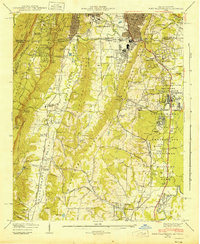 1942 Fort Oglethorpe1946 Print · USGSThe Tennessee-Georgia borderlands are captured here during the early 1940s, highlighting the transition from historic battlefields to growing residential communities. Genealogists and historians can trace family-named sites like Snodgrass House, McCallie Lake, and Lee and Gordon Mill.3 unique versions available
 - 1945 Map of Hooker, 1954 Print
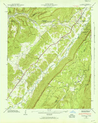 1945 Hooker1954 Print · USGSThe Georgia-Tennessee borderlands appear here in the mid-1940s, showing the intersection of heavy rail and mountain terrain. Genealogists can trace family landmarks like Sarah Chapel, West Brow Sch, and the Dickens Cem along the slopes of Lookout Mountain.2 unique versions available
 - 1946 Map of Hooker, 1947 Print
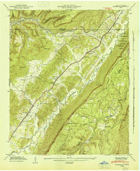 1946 Hooker1947 Print · USGSLookout Valley in the mid-1940s served as a vital rail corridor through the gaps of the Appalachians between Georgia and Tennessee. Genealogists can trace family footprints at Sarah Chapel, North Dade Sch, and Magill Cem along the winding course of Lookout Creek.2 unique versions available
End of results
Showing maps 1-3 of 3
Top cities near Lookout Mountain
- Chattanooga historical maps
- East Ridge historical maps
- East Ridge historical maps
- Soddy-Daisy historical maps
- Fort Oglethorpe historical maps
- Signal Mountain historical maps
See more
Top neighborhoods of Lookout Mountain
Frequently asked questions
- What are the different types of historical maps available for Lookout Mountain?
- What is the oldest map of Lookout Mountain?
- Where can I purchase historical maps of Lookout Mountain for my home or office?
- Where can I download high-res historical maps of Lookout Mountain?
- Are there historical topographic maps available for Lookout Mountain?
- Is there historical aerial imagery available for Lookout Mountain?
- Where are historical maps of Lookout Mountain sourced from?