1940s Maps of Masseyville, Georgia
Explore 2 historic maps of Masseyville from the 1940s. These maps offer a rare glimpse into what life looked like during the 1940s — showing old roads, neighborhoods, homes, and landmarks that have changed or disappeared over time.
Whether you're researching your family's past, planning a metal detecting trip, or studying how Masseyville's landscape evolved across the 1940s, these high-resolution maps are a powerful tool for exploring the history of this region.
- Focus on a specific era: All maps on this page are from the 1940s, giving you a focused view of this time period.
- See what’s changed: Compare century-old streets, trails, and buildings to today's modern landscape using overlays and satellite layers.
- Research with precision: Use these maps for genealogy, historical research, land use analysis, or educational projects.
- View, download, or print: Maps are fully viewable online in high resolution, and can be downloaded or printed for your own records.
Start exploring Masseyville's history through authentic maps from the 1940s. This is your window into the past.
Masseyville, GA maps
(2)- 1946 Map of Cedar Grove, 1960 Print
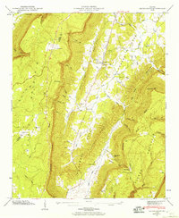 1946 Cedar Grove1960 Print · USGSWalker County at the end of the Second World War reveals a tightly knit landscape of mountain ridges and fertile valley coves. Researchers can locate family roots at Cedar Grove Cem or Thurman Cem, and trace old routes through McLemore Cove and Rape Gap.3 unique versions available
 - 1947 Map of Cedar Grove
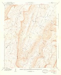 1947 Cedar Grove1947 Print · USGSWalker County, Georgia, is shown here in the late 1940s, documenting a landscape of steep ridges and fertile coves. Genealogists and historians can locate family landmarks like Thurman Cem, the community at Cedar Grove, and the winding path of Trickum Road.2 unique versions available
End of results
Showing maps 1-2 of 2
Top cities near Masseyville
- Fort Payne historical maps
- Fort Oglethorpe historical maps
- LaFayette historical maps
- Chickamauga historical maps
- Trenton historical maps
- Trion historical maps
See more
Frequently asked questions
- What are the different types of historical maps available for Masseyville?
- What is the oldest map of Masseyville?
- Where can I purchase historical maps of Masseyville for my home or office?
- Where can I download high-res historical maps of Masseyville?
- Are there historical topographic maps available for Masseyville?
- Is there historical aerial imagery available for Masseyville?
- Where are historical maps of Masseyville sourced from?