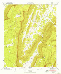
1946 Map of Cedar Grove
USGS Topo · Published 1960About this map
McLemore Cove dominates this 1946 field study of the northwest Georgia corridor, sitting between the towering heights of Lookout Mountain and Pigeon Mountain. This pocket of Walker County reveals a landscape defined by sharp ridges like Roland Ridge and deep, narrow gulfs such as McKaig Gulf and Kirkis Gulf. The settlement at Cedar Grove serves as a central hub for the valley, supported by local landmarks like Cedar Grove Ch and the Cedar Grove Cem.
Find a feature on this map
73 named features on this map. Tap any name to fly to it.
Don’t see what you’re looking for? This feature index may not catch every label — zoom into the map to look around manually.
Map Details
Editions of this 1946 Cedar Grove Map
3 editions found
Other maps of this area

1886 · Ringgold
USGS Topo · 1:125,000

1886 · Stevenson
USGS Topo · 1:125,000

1892 · Ringgold
USGS Topo · 1:125,000

1892 · Stevenson
USGS Topo · 1:125,000

1895 · Stevenson
USGS Topo · 1:125,000

1935 · Durham
USGS Topo · 1:24,000

1936 · Trenton
USGS Topo · 1:24,000

1936 · Kensington
USGS Topo · 1:24,000

1936 · Sulphur Springs
USGS Topo · 1:24,000

1936 · Estelle
USGS Topo · 1:24,000