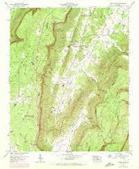
1946 Map of Cedar Grove
USGS Topo · Published 1972About this map
Lookout Mountain and Pigeon Mountain dominate this 1946 survey, framing the broad agricultural valley of Mclemore Cove. The landscape reveals a deeply established rural community centered around the settlement of Cedar Grove, where the Cedar Grove Ch and Cedar Grove Cem stand near the banks of Mill Creek. To the west, the rugged terrain of Tatum Gulf and McKaig Gulf cuts into the plateau, while Cloudland Canyon State Park marks a significant conservation area in Dade and Walker Counties.
Find a feature on this map
52 named features on this map. Tap any name to fly to it.
Don’t see what you’re looking for? This feature index may not catch every label — zoom into the map to look around manually.
Map Details
Editions of this 1946 Cedar Grove Map
3 editions found
Other maps of this area

1886 · Ringgold
USGS Topo · 1:125,000

1886 · Stevenson
USGS Topo · 1:125,000

1892 · Ringgold
USGS Topo · 1:125,000

1892 · Stevenson
USGS Topo · 1:125,000

1895 · Stevenson
USGS Topo · 1:125,000

1935 · Durham
USGS Topo · 1:24,000

1936 · Trenton
USGS Topo · 1:24,000

1936 · Kensington
USGS Topo · 1:24,000

1936 · Sulphur Springs
USGS Topo · 1:24,000

1936 · Estelle
USGS Topo · 1:24,000