1970s Maps of Ware County, Georgia
Explore 8 historic maps of Ware County from the 1970s. These maps offer a rare glimpse into what life looked like during the 1970s — showing old roads, neighborhoods, homes, and landmarks that have changed or disappeared over time.
Whether you're researching your family's past, planning a metal detecting trip, or studying how Ware County's landscape evolved across the 1970s, these high-resolution maps are a powerful tool for exploring the history of this region.
- Focus on a specific era: All maps on this page are from the 1970s, giving you a focused view of this time period.
- See what’s changed: Compare century-old streets, trails, and buildings to today's modern landscape using overlays and satellite layers.
- Research with precision: Use these maps for genealogy, historical research, land use analysis, or educational projects.
- View, download, or print: Maps are fully viewable online in high resolution, and can be downloaded or printed for your own records.
Start exploring Ware County's history through authentic maps from the 1970s. This is your window into the past.
Ware County, GA maps
(8)- 1971 Map of Dixie Union, 1974 Print
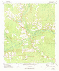
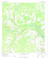 1971 Dixie Union1974 Print · USGSWare County in the early seventies is defined by the winding Satilla River and the rural communities of Dixie Union and Waresboro. Genealogists and local historians can trace old family sites near Jordan Ch or locate the era's local Drive-in Theater.2 unique versions available
 - 1971 Map of Wilsonville, 1974 Print
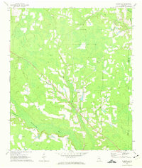 1971 Wilsonville1974 Print · USGSCoffee County and Ware County meet in this rural Georgia landscape during the early 1970s, as the Seventeen Mile River meanders through the pine-filled lowlands. Genealogists and local historians can trace family locations through several rural landmarks, including Little Geneva Cem, Forest Grove Ch, and the settlement at Wilsonville.
 - 1971 Map of Beach, 1974 Print
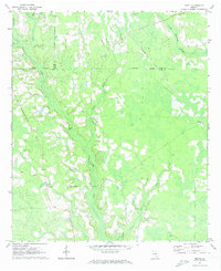 1971 Beach1974 Print · USGSSoutheast Georgia's rural timber and farm country comes into focus in the early 1970s as the rail and road networks connected small parish communities. Genealogists and local historians can trace family land near Bickley, Grace Chapel, and several local sites like Bagley Cem.2 unique versions available
 - 1971 Map of Axson, 1974 Print
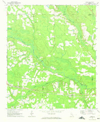 1971 Axson1974 Print · USGSSoutheast Georgia’s wiregrass country is documented here in the early 1970s, as the Seaboard Coast Line railroad linked timber and agricultural outposts. Researchers can trace the lineage of small communities through sites like Stokesville, Axson Cem, and Taylor Chapel.
 - 1971 Map of Talmo, 1974 Print
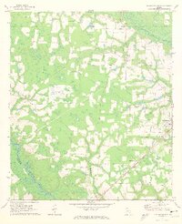
 1971 Talmo1974 Print · USGSWare County, Georgia, is captured here in the early 1970s as a landscape of river-bottom swamps and small railside settlements. Researchers can locate family landmarks like Chauncey Cem, the community at Fairfax, and churches such as Newborn Ch.2 unique versions available
 - 1971 Map of Blackshear West, 1974 Print
 1971 Blackshear West1974 Print · USGSPierce County in the early seventies reveals a landscape of river-bottom lowlands and rural community hubs. Researchers can locate family landmarks like Sweat Cem and Nunn Cem or trace the Seaboard Coast Line through Homestead.2 unique versions available
 - 1971 Map of Crawley, 1974 Print
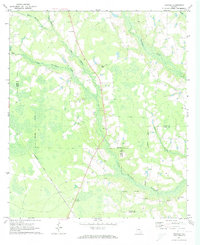 1971 Crawley1974 Print · USGSSoutheast Georgia in the early 1970s is defined here by the rural crossroads and wetlands at the meeting of three counties. Genealogists and historians can trace the Seaboard Coast Line through Crawley and Bolen, or locate family sites like Lee Chapel Cem and Old Pine Grove Ch.2 unique versions available
 - 1978 Map of Waycross, 1982 Print
 1978 Waycross1982 Print · USGSSoutheast Georgia in the late seventies is a landscape of vast wetlands and busy rail junctions. Genealogists and local historians can trace the Seaboard Coast Line through rural stops like Millwood and Pearson or locate family sites near the Okefenokee Swamp.
End of results
Showing maps 1-8 of 8
Top cities of Ware County
Frequently asked questions
- What are the different types of historical maps available for Ware County?
- What is the oldest map of Ware County?
- Where can I purchase historical maps of Ware County for my home or office?
- Where can I download high-res historical maps of Ware County?
- Are there historical topographic maps available for Ware County?
- Is there historical aerial imagery available for Ware County?
- Where are historical maps of Ware County sourced from?