1960s Maps of Tennille, Georgia
Explore 2 historic maps of Tennille from the 1960s. These maps offer a rare glimpse into what life looked like during the 1960s — showing old roads, neighborhoods, homes, and landmarks that have changed or disappeared over time.
Whether you're researching your family's past, planning a metal detecting trip, or studying how Tennille's landscape evolved across the 1960s, these high-resolution maps are a powerful tool for exploring the history of this region.
- Focus on a specific era: All maps on this page are from the 1960s, giving you a focused view of this time period.
- See what’s changed: Compare century-old streets, trails, and buildings to today's modern landscape using overlays and satellite layers.
- Research with precision: Use these maps for genealogy, historical research, land use analysis, or educational projects.
- View, download, or print: Maps are fully viewable online in high resolution, and can be downloaded or printed for your own records.
Start exploring Tennille's history through authentic maps from the 1960s. This is your window into the past.
Tennille, GA maps
(2)- 1962 Map of Sandersville, 1963 Print
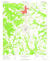 1962 Sandersville1963 Print · USGSThe Georgia coastal plain comes into focus in the early sixties, showing the industrial and social hubs of Washington County. Trace family history through local landmarks like Brownwood Cem, Elder High Sch, and the rail corridors of the Central of Georgia.3 unique versions available
 - 1964 Map of Macon
 1964 Macon1964 Print · USGSCentral Georgia in the mid-sixties is defined by its major river valleys and a booming military presence. Genealogists and historians can trace the growth of Warner Robins near Robins AFB or locate smaller rural junctions like Allentown and Jeffersonville along the historic Southern railroad lines.2 unique versions available
End of results
Showing maps 1-2 of 2
Top cities near Tennille
- Sandersville historical maps
- Wrightsville historical maps
- Davisboro historical maps
- Harrison historical maps
- Oconee historical maps
- Deepstep historical maps
See more
Frequently asked questions
- What are the different types of historical maps available for Tennille?
- What is the oldest map of Tennille?
- Where can I purchase historical maps of Tennille for my home or office?
- Where can I download high-res historical maps of Tennille?
- Are there historical topographic maps available for Tennille?
- Is there historical aerial imagery available for Tennille?
- Where are historical maps of Tennille sourced from?