1900s (20th Century) Maps of Tignall, Georgia
Explore 11 historic maps of Tignall from the 1900s (20th Century). These maps offer a rare glimpse into what life looked like during the 1900s — showing old roads, neighborhoods, homes, and landmarks that have changed or disappeared over time.
Whether you're researching your family's past, planning a metal detecting trip, or studying how Tignall's landscape evolved across the 1900s, these high-resolution maps are a powerful tool for exploring the history of this region.
- Focus on a specific era: All maps on this page are from the 1900s, giving you a focused view of this time period.
- See what’s changed: Compare century-old streets, trails, and buildings to today's modern landscape using overlays and satellite layers.
- Research with precision: Use these maps for genealogy, historical research, land use analysis, or educational projects.
- View, download, or print: Maps are fully viewable online in high resolution, and can be downloaded or printed for your own records.
Start exploring Tignall's history through authentic maps from the 1900s. This is your window into the past.
Tignall, GA maps
(11)- 1906 Map of Crawfordville
 1906 Crawfordville1906 Print · USGSUpper Georgia and the South Carolina border come alive in this early century survey, showing a landscape defined by river ferries and mining sites. Genealogists can trace family roots through old post offices like Triplett P.O. or find historic crossings like Fishdam Ferry and the Columbia Mines.3 unique versions available
 - 1953 Map of Athens, 1966 Print
 1953 Athens1966 Print · USGSGeorgia's Piedmont and Savannah River borderlands come alive in this mid-century survey of the region surrounding Athens and Augusta. Trace the rail-and-river economy through the Georgia RR and landmarks like the Fort Gordon Military Reservation.3 unique versions available
 - 1955 Map of Tignall, 1956 Print
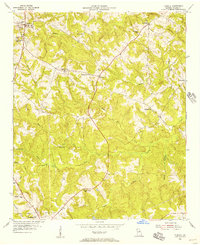 1955 Tignall1956 Print · USGSWilkes County during the mid-fifties reveals a landscape of rural schoolhouses and small crossroads settlements connected by the winding path of Georgia Highway 17. Genealogists and researchers can trace local landmarks like Rosenwald High Sch, Reeves Chapel Sch, and the community of Danburg.2 unique versions available
 - 1955 Map of Broad, 1956 Print
 1955 Broad1956 Print · USGSWilkes and Elbert counties meet along the Broad River in the mid-1950s as the rising waters of Clark Hill Reservoir begin to transform the landscape. Family historians can trace rural congregations and early schools like Popes Chapel, Tabor Ch, and Pole Branch Sch.2 unique versions available
 - 1958 Map of Athens
 1958 Athens1958 Print · USGSNorth-central Georgia and the Savannah River valley are captured in the late fifties, showing the region as the new reservoirs were filling. Researchers can trace historic rail lines like the Georgia RR and locate rural landmarks such as Social Circle, Graves Mountain, and the Fort Gordon Military Reservation.
 - 1959 Map of Athens
 1959 Athens1959 Print · USGSNortheast Georgia and the South Carolina borderlands appear here in the mid-fifties, during a decade of infrastructure growth. Genealogists and historians can trace the rail-and-river geography of towns like Social Circle, the sprawl of Fort Gordon Military Reservation, and the newly formed Clark Hill Reservoir.
 - 1963 Map of Athens
 1963 Athens1963 Print · USGSGeorgia's Piedmont and the Savannah River valley are captured in the early sixties as major reservoirs and military installations reshaped the landscape. Researchers can trace the development of Clark Hill Reservoir, locate the Fort Gordon Military Reservation, and find historic towns like Social Circle and Eatonton.
 - 1970 Map of Jacksons Crossroads, 1973 Print
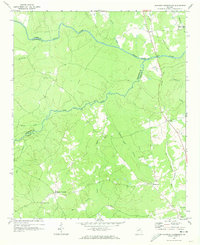 1970 Jacksons Crossroads1973 Print · USGSWilkes County and its neighbors come alive in the early 1970s as the Broad River winds through a landscape of historic small settlements. Researchers can trace the Old Railroad Grade and locate ancestral sites like Mallorysville, Clark Station Ch, and St Johns Cem.
 - 1971 Map of Celeste, 1973 Print
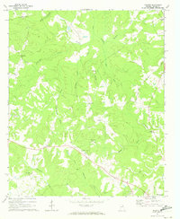 1971 Celeste1973 Print · USGSWilkes County at the start of the 1970s reveals a Piedmont landscape where historic rural settlements like Linesville and Celeste remained centered around their country churches. You can trace the Old Railroad Grade and locate family landmarks such as Jacksons Store and Hilliard Station Ch.
 - 1980 Map of Clark Hill Lake, 1981 Print
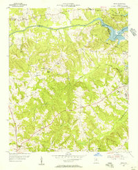
 1980 Clark Hill Lake1981 Print · USGSThe Georgia and South Carolina borderlands in the early eighties were defined by the expansive Clark Hill Lake and the winding Savannah River. Genealogists and historians can trace rail lines like the Georgia Railroad, find the De La Howe State School, and locate rural centers like Tignall and Appling.
 - 1988 Map of Athens
 1988 Athens1988 Print · USGSThe Georgia Piedmont and South Carolina borderlands appear in the late eighties as a landscape of vast reservoirs and growing towns. Researchers can trace the legacy of the Georgia RR connecting Athens and Augusta, or locate landmarks within Oconee National Forest.
End of results
Showing maps 1-11 of 11
Top cities near Tignall
- Elberton historical maps
- Washington historical maps
- Calhoun Falls historical maps
- Rayle historical maps
Frequently asked questions
- What are the different types of historical maps available for Tignall?
- What is the oldest map of Tignall?
- Where can I purchase historical maps of Tignall for my home or office?
- Where can I download high-res historical maps of Tignall?
- Are there historical topographic maps available for Tignall?
- Is there historical aerial imagery available for Tignall?
- Where are historical maps of Tignall sourced from?