1950s Maps of Captain Cook, Hawaii
Explore 3 historic maps of Captain Cook from the 1950s. These maps offer a rare glimpse into what life looked like during the 1950s — showing old roads, neighborhoods, homes, and landmarks that have changed or disappeared over time.
Whether you're researching your family's past, planning a metal detecting trip, or studying how Captain Cook's landscape evolved across the 1950s, these high-resolution maps are a powerful tool for exploring the history of this region.
- Focus on a specific era: All maps on this page are from the 1950s, giving you a focused view of this time period.
- See what’s changed: Compare century-old streets, trails, and buildings to today's modern landscape using overlays and satellite layers.
- Research with precision: Use these maps for genealogy, historical research, land use analysis, or educational projects.
- View, download, or print: Maps are fully viewable online in high resolution, and can be downloaded or printed for your own records.
Start exploring Captain Cook's history through authentic maps from the 1950s. This is your window into the past.
Captain Cook, HI maps
(3)- 1954 Map of Hawaii South
 1954 Hawaii South1954 Print · USGSThe southern reaches of the Big Island in the mid-fifties show a landscape of volcanic peaks, coastal villages, and upland timber mills. Researchers can trace the old island infrastructure through sites like Koa Mill, Hoopuloa, and the remote Mountain House.
 - 1959 Map of Hawaii South
 1959 Hawaii South1959 Print · USGSThe southern half of the Big Island appears here in the late fifties, dominated by the active volcanic peaks and extensive forest reserves. Researchers can trace the mid-century footprints of Pahala, Waiohinu, and the agricultural grounds of Gaspard Dairy.
 - 1959 Map of Honaunau, 1960 Print
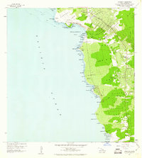 1959 Honaunau1960 Print · USGSCoastal South Kona is captured here during the late fifties, as traditional coffee farming and coastal villages defined the landscape. Genealogists and historians can trace family locations near the Coffee Mill, Napoopoo School, or the City of Refuge National Historical Park.2 unique versions available
End of results
Showing maps 1-3 of 3
Frequently asked questions
- What are the different types of historical maps available for Captain Cook?
- What is the oldest map of Captain Cook?
- Where can I purchase historical maps of Captain Cook for my home or office?
- Where can I download high-res historical maps of Captain Cook?
- Are there historical topographic maps available for Captain Cook?
- Is there historical aerial imagery available for Captain Cook?
- Where are historical maps of Captain Cook sourced from?