1980s Maps of Hawaiian Beaches, Hawaii
Explore 4 historic maps of Hawaiian Beaches from the 1980s. These maps offer a rare glimpse into what life looked like during the 1980s — showing old roads, neighborhoods, homes, and landmarks that have changed or disappeared over time.
Whether you're researching your family's past, planning a metal detecting trip, or studying how Hawaiian Beaches's landscape evolved across the 1980s, these high-resolution maps are a powerful tool for exploring the history of this region.
- Focus on a specific era: All maps on this page are from the 1980s, giving you a focused view of this time period.
- See what’s changed: Compare century-old streets, trails, and buildings to today's modern landscape using overlays and satellite layers.
- Research with precision: Use these maps for genealogy, historical research, land use analysis, or educational projects.
- View, download, or print: Maps are fully viewable online in high resolution, and can be downloaded or printed for your own records.
Start exploring Hawaiian Beaches's history through authentic maps from the 1980s. This is your window into the past.
Hawaiian Beaches, HI maps
(4)- 1980 Map of Pahoa South, 1981 Print
 1980 Pahoa South1981 Print · USGSThe Puna District of Hawaii comes into focus during the early eighties, showing a landscape shaped by recent volcanic activity and modern homesteading. Researchers can trace the path of the Lava Flow of 1955 through coastal tracts or locate historic sites like Kaniahiku Village and the Old Railroad Grade.
 - 1980 Map of Hawaii County Sheet 2, 1985 Print
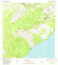
 1980 Hawaii County Sheet 21985 Print · USGSThe eastern coast of the Big Island is captured here in the early eighties, showcasing the intersection of active volcanic landforms and historic plantation towns. Researchers can trace family roots through settlements like Laupahoehoe and Papaikou, or explore the road networks around Kilauea Crater and General Lyman Field.
 - 1981 Map of Kapoho
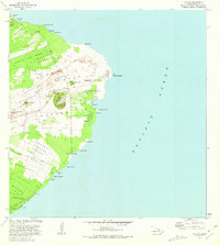 1981 Kapoho1981 Print · USGSThe Puna coastline is captured here in the early eighties, showing a landscape transformed by the Lava Flow of 1960 and earlier eruptions. Researchers can find archaeological sites like Kukii Heiau, coastal landmarks like Cape Kumukahi, and local features such as Green Lake.
 - 1981 Map of Pahoa North
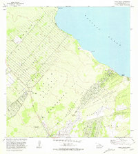 1981 Pahoa North1981 Print · USGSThe Puna coastline and the burgeoning subdivisions north of Pahoa are documented here in the early eighties. Genealogists and historians can locate family holdings in the Nanawale Homesteads or trace the historical site of Makuu and Honolulu Landing.2 unique versions available
End of results
Showing maps 1-4 of 4
Top cities near Hawaiian Beaches
Top neighborhoods of Hawaiian Beaches
Frequently asked questions
- What are the different types of historical maps available for Hawaiian Beaches?
- What is the oldest map of Hawaiian Beaches?
- Where can I purchase historical maps of Hawaiian Beaches for my home or office?
- Where can I download high-res historical maps of Hawaiian Beaches?
- Are there historical topographic maps available for Hawaiian Beaches?
- Is there historical aerial imagery available for Hawaiian Beaches?
- Where are historical maps of Hawaiian Beaches sourced from?