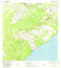
1980 Map of Pahoa South
USGS Topo · Published 1981About this map
The East Rift Zone defines the volcanic character of this Puna District landscape, where the devastating Lava Flow of 1955 is recorded cutting across the Kamaili Homesteads and reaching the Pacific Ocean. This survey captures the Puna coast in 1980, a time of transition between traditional agricultural homesteads and modern geothermal exploration, evidenced by the Geothermal Well near Puu Kepaka. Settlement clusters around the inland hub of Pahoa and the coastal village of Opihikao, with an extensive network of homestead tracts like Keokea and Keauohana revealing the long history of land division in the region. Notable landmarks including Lava Tree State Park and Mackenzie State Park flank the shoreline, while the presence of the Old Railroad Grade and the Univ of Hawaii Experimental Station reflect the area's economic evolution from rail-era transport to scientific research.
Find a feature on this map
86 named features on this map. Tap any name to fly to it.
Don’t see what you’re looking for? This feature index may not catch every label — zoom into the map to look around manually.
Map Details
Editions of this 1980 Pahoa South Map
This is the sole edition of this map. No revisions or reprints were ever made.
Other maps of this area

1917 · Hilo
USGS Topo · 1:62,500

1922 · Puna
USGS Topo · 1:62,500

1924 · Makuu
USGS Topo · 1:62,500

1924 · Puna
USGS Topo · 1:62,500

1924 · Kalapana
USGS Topo · 1:62,500

1932 · Hilo
USGS Topo · 1:62,500

1954 · Hawaii South
USGS Topo · 1:250,000

1954 · Hawaii North
USGS Topo · 1:250,000

1959 · Hawaii South
USGS Topo · 1:250,000

1959 · Hawaii North
USGS Topo · 1:250,000