1920s Maps of Volcano, Hawaii
Explore 4 historic maps of Volcano from the 1920s. These maps offer a rare glimpse into what life looked like during the 1920s — showing old roads, neighborhoods, homes, and landmarks that have changed or disappeared over time.
Whether you're researching your family's past, planning a metal detecting trip, or studying how Volcano's landscape evolved across the 1920s, these high-resolution maps are a powerful tool for exploring the history of this region.
- Focus on a specific era: All maps on this page are from the 1920s, giving you a focused view of this time period.
- See what’s changed: Compare century-old streets, trails, and buildings to today's modern landscape using overlays and satellite layers.
- Research with precision: Use these maps for genealogy, historical research, land use analysis, or educational projects.
- View, download, or print: Maps are fully viewable online in high resolution, and can be downloaded or printed for your own records.
Start exploring Volcano's history through authentic maps from the 1920s. This is your window into the past.
Volcano, HI maps
(4)- 1921 Map of Kilauea, 1954 Print
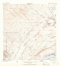 1921 Kilauea1954 Print · USGSThe volcanic heart of the Big Island is captured here in the early twentieth century, showing the intersection of geological wonder and early territorial development. Genealogists and historians can locate early family lands at the Wood Valley Homesteads or trace the routes of the Old Kau-Volcano Trail and the Old Puna-Kau Trail.2 unique versions available
 - 1922 Map of Puna, 1957 Print
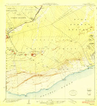
 1922 Puna1957 Print · USGSThe Puna district of Hawaii is captured here during the early twentieth century as the national park was taking shape. Researchers can locate ancient coastal sites like Wahaula Heiau and early homesteads at Kilauea Settlement Lots.
 - 1924 Map of Kilauea
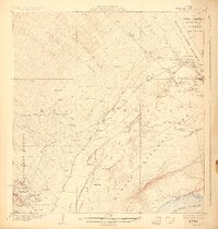 1924 Kilauea1924 Print · USGSThe volcanic highlands of Hawaii Island are captured here during a period of active transformation in the early twenties. Researchers can trace the early hospitality and military sites at Volcano House and Kilauea Military Camp, plus working landscapes like Keauhou Ranch.5 unique versions available
 - 1924 Map of Puna
 1924 Puna1924 Print · USGSThe Puna coastline and the volcanic highlands of Hawaii are captured here in the early twenties, during the growth of local homesteading and ranching. Genealogists and historians can locate early residents in the Kilauea Settlement Lots or trace the path of the Hawaii Consolidated Ry near Glenwood.2 unique versions available
End of results
Showing maps 1-4 of 4
Top cities near Volcano
Top neighborhoods of Volcano
Frequently asked questions
- What are the different types of historical maps available for Volcano?
- What is the oldest map of Volcano?
- Where can I purchase historical maps of Volcano for my home or office?
- Where can I download high-res historical maps of Volcano?
- Are there historical topographic maps available for Volcano?
- Is there historical aerial imagery available for Volcano?
- Where are historical maps of Volcano sourced from?